1960s Maps of Rolesville, North Carolina
Explore 2 historic maps of Rolesville from the 1960s. These maps offer a rare glimpse into what life looked like during the 1960s — showing old roads, neighborhoods, homes, and landmarks that have changed or disappeared over time.
Whether you're researching your family's past, planning a metal detecting trip, or studying how Rolesville's landscape evolved across the 1960s, these high-resolution maps are a powerful tool for exploring the history of this region.
- Focus on a specific era: All maps on this page are from the 1960s, giving you a focused view of this time period.
- See what’s changed: Compare century-old streets, trails, and buildings to today's modern landscape using overlays and satellite layers.
- Research with precision: Use these maps for genealogy, historical research, land use analysis, or educational projects.
- View, download, or print: Maps are fully viewable online in high resolution, and can be downloaded or printed for your own records.
Start exploring Rolesville's history through authentic maps from the 1960s. This is your window into the past.
Rolesville, NC maps
(2)- 1967 Map of Rolesville, 1972 Print
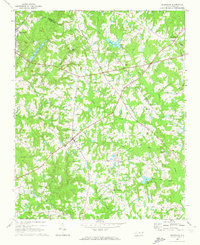 1967 Rolesville1972 Print · USGSWake County and Franklin County are captured in the late sixties as traditional agricultural crossroads begin to meet modern utility. Genealogists and local historians can trace family roots through Rolesville Cem or locate old community centers like Fowlers Crossroads and Harris Crossroads.3 unique versions available
 - 1967 Map of Wake Forest, 1972 Print
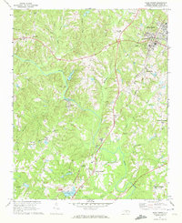 1967 Wake Forest1972 Print · USGSNorthern Wake County in the late sixties shows a landscape of growing crossroads and river communities centered around Wake Forest. Genealogists can locate family landmarks at Stony Hill Ch, Forestville, and the historic Southeastern Theological Seminary campus.6 unique versions available
End of results
Showing maps 1-2 of 2
Top cities near Rolesville
- Raleigh historical maps
- Wake Forest historical maps
- Clayton historical maps
- Garner historical maps
- Wendell historical maps
- Zebulon historical maps
See more
Top neighborhoods of Rolesville
- Lillian Y. Weathers historical maps
- Pine Glen historical maps
- Preserve at Jones Dairy South historical maps
- Terrell Plantation historical maps
- Wall Creek historical maps
- Watkins Farm historical maps
See more
Frequently asked questions
- What are the different types of historical maps available for Rolesville?
- What is the oldest map of Rolesville?
- Where can I purchase historical maps of Rolesville for my home or office?
- Where can I download high-res historical maps of Rolesville?
- Are there historical topographic maps available for Rolesville?
- Is there historical aerial imagery available for Rolesville?
- Where are historical maps of Rolesville sourced from?