1960s Maps of Warren County, North Carolina
Explore 7 historic maps of Warren County from the 1960s. These maps offer a rare glimpse into what life looked like during the 1960s — showing old roads, neighborhoods, homes, and landmarks that have changed or disappeared over time.
Whether you're researching your family's past, planning a metal detecting trip, or studying how Warren County's landscape evolved across the 1960s, these high-resolution maps are a powerful tool for exploring the history of this region.
- Focus on a specific era: All maps on this page are from the 1960s, giving you a focused view of this time period.
- See what’s changed: Compare century-old streets, trails, and buildings to today's modern landscape using overlays and satellite layers.
- Research with precision: Use these maps for genealogy, historical research, land use analysis, or educational projects.
- View, download, or print: Maps are fully viewable online in high resolution, and can be downloaded or printed for your own records.
Start exploring Warren County's history through authentic maps from the 1960s. This is your window into the past.
Warren County, NC maps
(7)- 1962 Map of Greensboro
 1962 Greensboro1962 Print · USGSThe Piedmont region along the Virginia and North Carolina border comes alive in the early 1960s, showing a landscape defined by industry and new reservoirs. Trace the path of the Virginian RR or explore the early development of Greensboro and Durham.
 - 1963 Map of Essex, 1964 Print
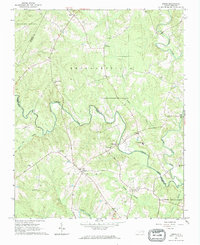 1963 Essex1964 Print · USGSCoastal plain farmland and tangled creek bottoms define this North Carolina borderland in the early sixties. Genealogists can trace family names at Lynch Cem and Silver Cem, or locate rural landmarks like Aventon and the local Brickyards.2 unique versions available
 - 1963 Map of Gasburg, 1964 Print
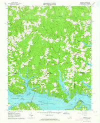 1963 Gasburg1964 Print · USGSThe Virginia and North Carolina borderlands appear in transition during the early sixties as the newly formed Lake Gaston reshapes the landscape. Local historians can trace family roots through numerous sites like Ebony, St Pauls Chapel, and Kirkland Cem.4 unique versions available
 - 1966 Map of Greensboro
 1966 Greensboro1966 Print · USGSThe North Carolina and Virginia Piedmont thrives during the mid-sixties, showcasing a landscape of textile hubs and expanding river reservoirs. Researchers can trace the rail corridors of the Southern Railway, find local landmarks like Elon College, or locate the extensive Camp Butner Military Reservation.
 - 1968 Map of South Hill SE, 1972 Print
 1968 South Hill SE1972 Print · USGSThe Roanoke River valley is shown transformed by the waters of Lake Gaston in the late sixties as the border region adapted to its new shoreline. Genealogists can trace numerous rural congregations and crossroads, including Barker Crossroads, Five Forks, and Holly Grove Ch.3 unique versions available
 - 1968 Map of Bracey, 1972 Print
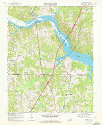 1968 Bracey1972 Print · USGSThe Virginia-North Carolina border country is shown here in the late sixties as the reservoir of Lake Gaston reshaped the local geography. Genealogists and historians can locate rural landmarks like Roanoke Zion Ch, Southside Sch, and the Seaboard Coast Line rail corridor.4 unique versions available
 - 1968 Map of John H Kerr Dam, 1972 Print
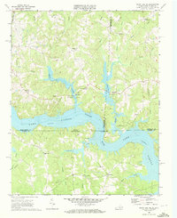
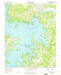 1968 John H Kerr Dam1972 Print · USGSThe Roanoke River valley is seen here just after the mid-century creation of major reservoirs along the Virginia and North Carolina border. Genealogists and local historians can trace the foundations of communities like Castle Heights and rural landmarks such as Lands Chapel and Jerusalem Ch.4 unique versions available
End of results
Showing maps 1-7 of 7
Top cities of Warren County
Frequently asked questions
- What are the different types of historical maps available for Warren County?
- What is the oldest map of Warren County?
- Where can I purchase historical maps of Warren County for my home or office?
- Where can I download high-res historical maps of Warren County?
- Are there historical topographic maps available for Warren County?
- Is there historical aerial imagery available for Warren County?
- Where are historical maps of Warren County sourced from?