Old Maps of Warren County, North Carolina for Academic Research
Study the evolution of Warren County with 97 high-resolution historic maps. Whether you're teaching, researching, or modeling changes in land use, these maps provide essential visual documentation of urban, environmental, and geographic change.
- Analyze long-term change: Track patterns in development, transportation, and natural features.
- Ideal for environmental or urban studies: Support academic projects with primary historical map data.
- Use in the classroom or lab: Educators and researchers rely on these maps to bring historical context to life.
These maps are a powerful tool for teaching, research, and visualizing how Warren County has changed over the decades.
Warren County, NC maps
(97)- 1919 Map of White Plains
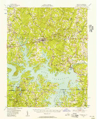
 1919 White Plains1919 Print · USGSSouthern Virginia and the North Carolina borderlands are captured here at the close of the Great War. Genealogists can trace early twentieth-century communities through family-named landmarks like Vincents Store, Hicks Mill, and Holly Springs Church.
 - 1920 Map of White Plains
 1920 White Plains1920 Print · USGSThe Virginia and North Carolina borderlands come to life in this 1920 survey of the Meherrin and Roanoke river basins. Genealogists can trace family names at Drumgoole Store and Phipps Store, or locate old schoolhouse sites like Meherrin School and Webb School.4 unique versions available
 - 1953 Map of Norfolk, 1954 Print
 1953 Norfolk1954 Print · USGSCoastal Virginia and northeastern North Carolina appear here during the post-war industrial boom, showing the critical rail-and-sea connections of Hampton Roads. Genealogists can trace family roots through rural landmarks like Gethsemane Ch, the Caledonia State Prison Farm, and the vast interior of the Dismal Swamp.4 unique versions available
 - 1953 Map of Greensboro, 1981 Print
 1953 Greensboro1981 Print · USGSThe Piedmont borderlands of North Carolina and Virginia show a landscape defined by new reservoirs and old rail lines. Trace family roots and the changing river geography through Elon College, the John H Kerr Reservoir, and South Boston.
 - 1954 Map of Greensboro
 1954 Greensboro1954 Print · USGSThe Piedmont borderlands of North Carolina and Virginia come alive in this mid-fifties study of a region defined by its rivers and rails. Researchers can trace the growing Buggs Island Lake or follow the paths of the Southern Ry and Seaboard Air Line RR through towns like Oxford and Reidsville.
 - 1955 Map of Boydton, 1957 Print
 1955 Boydton1957 Print · USGSMecklenburg County and the Virginia-North Carolina border are shown here during the mid-fifties, just as the newly formed Kerr Reservoir reshaped the Roanoke River valley. Genealogists and local historians can trace family-named sites like Dodson Corner and Rogers Corner or locate vanished landmarks like Island Hill Sch.2 unique versions available
 - 1962 Map of Greensboro
 1962 Greensboro1962 Print · USGSThe Piedmont region along the Virginia and North Carolina border comes alive in the early 1960s, showing a landscape defined by industry and new reservoirs. Trace the path of the Virginian RR or explore the early development of Greensboro and Durham.
 - 1963 Map of Essex, 1964 Print
 1963 Essex1964 Print · USGSCoastal plain farmland and tangled creek bottoms define this North Carolina borderland in the early sixties. Genealogists can trace family names at Lynch Cem and Silver Cem, or locate rural landmarks like Aventon and the local Brickyards.2 unique versions available
 - 1963 Map of Gasburg, 1964 Print
 1963 Gasburg1964 Print · USGSThe Virginia and North Carolina borderlands appear in transition during the early sixties as the newly formed Lake Gaston reshapes the landscape. Local historians can trace family roots through numerous sites like Ebony, St Pauls Chapel, and Kirkland Cem.4 unique versions available
 - 1966 Map of Greensboro
 1966 Greensboro1966 Print · USGSThe North Carolina and Virginia Piedmont thrives during the mid-sixties, showcasing a landscape of textile hubs and expanding river reservoirs. Researchers can trace the rail corridors of the Southern Railway, find local landmarks like Elon College, or locate the extensive Camp Butner Military Reservation.
 - 1968 Map of South Hill SE, 1972 Print
 1968 South Hill SE1972 Print · USGSThe Roanoke River valley is shown transformed by the waters of Lake Gaston in the late sixties as the border region adapted to its new shoreline. Genealogists can trace numerous rural congregations and crossroads, including Barker Crossroads, Five Forks, and Holly Grove Ch.3 unique versions available
 - 1968 Map of Bracey, 1972 Print
 1968 Bracey1972 Print · USGSThe Virginia-North Carolina border country is shown here in the late sixties as the reservoir of Lake Gaston reshaped the local geography. Genealogists and historians can locate rural landmarks like Roanoke Zion Ch, Southside Sch, and the Seaboard Coast Line rail corridor.4 unique versions available
 - 1968 Map of John H Kerr Dam, 1972 Print
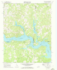
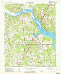
 1968 John H Kerr Dam1972 Print · USGSThe Roanoke River valley is seen here just after the mid-century creation of major reservoirs along the Virginia and North Carolina border. Genealogists and local historians can trace the foundations of communities like Castle Heights and rural landmarks such as Lands Chapel and Jerusalem Ch.4 unique versions available
 - 1970 Map of Macon, 1973 Print
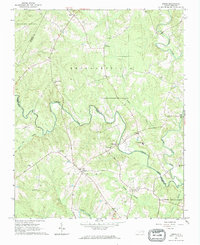
 1970 Macon1973 Print · USGSWarren County at the start of the 1970s reveals a landscape of rural communities connected by the Seaboard Coast Line railroad. You can trace the historic layout of Macon and Vaughan alongside rural landmarks like Greenwood Ch and Oakville.2 unique versions available
 - 1970 Map of Vicksboro, 1973 Print
 1970 Vicksboro1973 Print · USGSVance County in the early seventies was a land of small crossroads communities and family-named creek branches. Researchers can trace the legacy of rural life through landmarks like Weldons Mill, the Seaboard Coast Line rail route, and local churches such as Hughes Grove Ch.
 - 1970 Map of Middleburg, 1973 Print
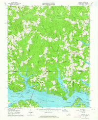
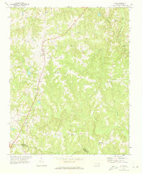
 1970 Middleburg1973 Print · USGSVance and Warren counties are shown here in the early 1970s as the regional landscape adjusted to the reservoir shoreline and the development of Soul City. Researchers can trace local heritage through the Seaboard Coast Line rail stops and rural landmarks like Nutbush Sch and Morning Star Ch.2 unique versions available
 - 1970 Map of Warrenton, 1973 Print
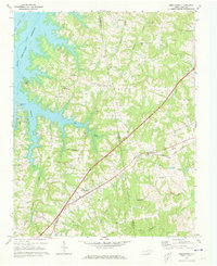
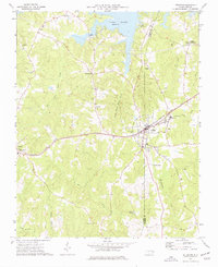
 1970 Warrenton1973 Print · USGSWarren County at the start of the seventies centered on the rail junction at Norlina and the county seat of Warrenton. Genealogists can trace family names at Old Warrenton Cem or explore rural community life at Warren Plains and Snow Hill.
 - 1971 Map of Inez, 1973 Print
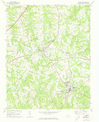
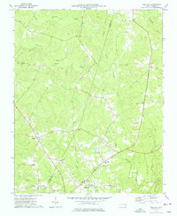
 1971 Inez1973 Print · USGSWarren County at the start of the seventies reveals a landscape of enduring rural crossroads and creek-side settlements. Genealogists and local historians can trace the foundations of Inez, Grove Hill, and Liberia, alongside landmarks like Shady Grove Ch and the Lookout Tower.
 - 1971 Map of Afton, 1973 Print
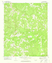
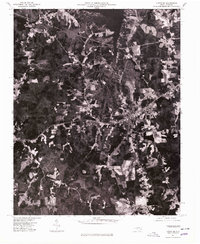
 1971 Afton1973 Print · USGSThe rural communities of Warren County come into focus in the early 1970s, organized around country roads and woodland creeks. Genealogists can trace family roots through numerous sites like Warren Academy, Sulphur Springs Ch, and the settlement at Elberon.
 - 1973 Map of Hollister, 1977 Print
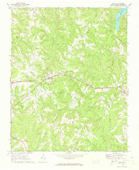
 1973 Hollister1977 Print · USGSThe rural borderlands of Halifax and Warren Counties come into focus in the early 1970s, showing a landscape defined by creeks and country roads. Genealogists can locate family landmarks like White Rock Ch, Lees Chapel, and the timber-era remnants of the Porter Grade.
 - 1973 Map of Littleton, 1977 Print
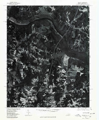
 1973 Littleton1977 Print · USGSThe border of Warren and Halifax Counties in the early 1970s is captured here as the Seaboard Coast Line passes through several rural communities. Researchers can trace the layout of Littleton, find Panacea Springs, and locate country churches like Ashley Grove Ch.
 - 1977 Map of Middleburg, 1978 Print
 1977 Middleburg1978 Print · USGSThe North Carolina countryside appears in sharp detail in the late 1970s, showing the intersection of agricultural life and major transit lines. Researchers can trace the footprints of Middleburg, Manson, and Drewry alongside the John H Kerr Reservoir.
 - 1977 Map of John H Kerr Dam, 1978 Print
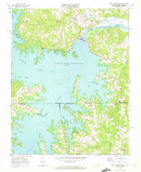
 1977 John H Kerr Dam1978 Print · USGSThe Mecklenburg County borderlands appear in high-contrast aerial detail during the late seventies, showing the managed waters of the John H Kerr Reservoir. Researchers can trace the sprawling shoreline and rural tracts near Rose Hill and the massive John H Kerr Dam.
 - 1977 Map of Bracey, 1979 Print
 1977 Bracey1979 Print · USGSThe Roanoke River valley and the Virginia-North Carolina borderlands are seen here in the late seventies. Researchers can trace the sprawling shoreline of Lake Gaston and locate regional crossroads like Bracey and Palmer Springs.
 - 1977 Map of Littleton, 1979 Print
 1977 Littleton1979 Print · USGSThe town of Littleton and the southern shores of Lake Gaston are captured in this late-seventies aerial survey of the North Carolina interior. Genealogists and historians can examine the precise layout of Littleton and nearby Vaughan or trace the timberlines near Enterprise.
Showing maps 1-25 of 97
Top cities of Warren County
Frequently asked questions
- What are the different types of historical maps available for Warren County?
- What is the oldest map of Warren County?
- Where can I purchase historical maps of Warren County for my home or office?
- Where can I download high-res historical maps of Warren County?
- Are there historical topographic maps available for Warren County?
- Is there historical aerial imagery available for Warren County?
- Where are historical maps of Warren County sourced from?