1990s Maps of Plymouth, North Carolina
Explore 2 historic maps of Plymouth from the 1990s. These maps offer a rare glimpse into what life looked like during the 1990s — showing old roads, neighborhoods, homes, and landmarks that have changed or disappeared over time.
Whether you're researching your family's past, planning a metal detecting trip, or studying how Plymouth's landscape evolved across the 1990s, these high-resolution maps are a powerful tool for exploring the history of this region.
- Focus on a specific era: All maps on this page are from the 1990s, giving you a focused view of this time period.
- See what’s changed: Compare century-old streets, trails, and buildings to today's modern landscape using overlays and satellite layers.
- Research with precision: Use these maps for genealogy, historical research, land use analysis, or educational projects.
- View, download, or print: Maps are fully viewable online in high resolution, and can be downloaded or printed for your own records.
Start exploring Plymouth's history through authentic maps from the 1990s. This is your window into the past.
Plymouth, NC maps
(2)- 1998 Map of Plymouth East, 2001 Print
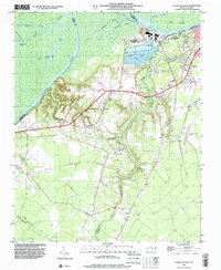
 1998 Plymouth East2001 Print · USGSCoastal North Carolina near the end of the century reveals a landscape defined by the Roanoke River and the edges of the East Dismal Swamp. Genealogists can trace local landmarks like Lily Valley Ch, Union Chapel, and the Tide Water Experimental Station.
 - 1998 Map of Plymouth West, 2001 Print
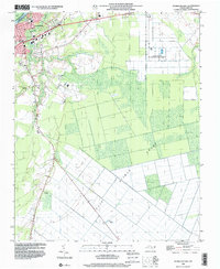
 1998 Plymouth West2001 Print · USGSMartin County in the late 1990s is captured here at the intersection of river-driven industry and deep rural heritage. Researchers can trace the layout of Plymouth and locate rural landmarks such as Poplar Chapel, Corinth Ch, and the small settlement of Dardens.
End of results
Showing maps 1-2 of 2
Top cities near Plymouth
Top neighborhoods of Plymouth
Frequently asked questions
- What are the different types of historical maps available for Plymouth?
- What is the oldest map of Plymouth?
- Where can I purchase historical maps of Plymouth for my home or office?
- Where can I download high-res historical maps of Plymouth?
- Are there historical topographic maps available for Plymouth?
- Is there historical aerial imagery available for Plymouth?
- Where are historical maps of Plymouth sourced from?