1980s Maps of Wilson County, North Carolina
Explore 5 historic maps of Wilson County from the 1980s. These maps offer a rare glimpse into what life looked like during the 1980s — showing old roads, neighborhoods, homes, and landmarks that have changed or disappeared over time.
Whether you're researching your family's past, planning a metal detecting trip, or studying how Wilson County's landscape evolved across the 1980s, these high-resolution maps are a powerful tool for exploring the history of this region.
- Focus on a specific era: All maps on this page are from the 1980s, giving you a focused view of this time period.
- See what’s changed: Compare century-old streets, trails, and buildings to today's modern landscape using overlays and satellite layers.
- Research with precision: Use these maps for genealogy, historical research, land use analysis, or educational projects.
- View, download, or print: Maps are fully viewable online in high resolution, and can be downloaded or printed for your own records.
Start exploring Wilson County's history through authentic maps from the 1980s. This is your window into the past.
Wilson County, NC maps
(5)- 1980 Map of Pinetops, 1981 Print
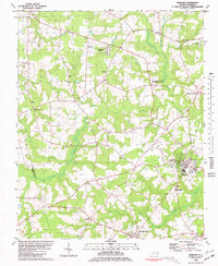 1980 Pinetops1981 Print · USGSEdgecombe County was a landscape of established rail towns and rural church communities in the late 1970s. Trace family roots and local history through landmarks like Temperance Hall, the streets of Pinetops, and centers of worship such as Morning Star Ch.
 - 1981 Map of Fountain, 1982 Print
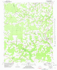 1981 Fountain1982 Print · USGSCoastal plain agriculture and small-town life in the early eighties center on the rural crossroads of Pitt and Edgecombe counties. Trace the roots of local communities at Piney Grove Sch, an Old Railroad Grade, and Webbtown Ch.
 - 1981 Map of Walstonburg, 1982 Print
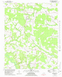 1981 Walstonburg1982 Print · USGSGreene County agriculture and community life are captured in detail here during the early eighties. Genealogists and historians can trace family roots through numerous rural landmarks like Speights Bridge, North Greene Sch, and Meadow Ch.
 - 1984 Map of Raleigh, 1985 Print
 1984 Raleigh1985 Print · USGSThe North Carolina Research Triangle is shown during a decade of rapid growth, from the sprawl of Raleigh to the expanding waters of Falls Lake. Genealogists and historians can trace rail lines like the Seaboard Coast Line or locate landmark sites like Dorothea Dix State Hospital and Fuquay-Varina.
 - 1985 Map of Rocky Mount
 1985 Rocky Mount1985 Print · USGSThe eastern North Carolina coastal plain in the mid-eighties shows a landscape defined by its river-and-rail heritage. Genealogists and local historians can trace the development of Rocky Mount, Greenville, and Wilson, or locate landmarks like East Carolina University and the Voice of America site.2 unique versions available
End of results
Showing maps 1-5 of 5
Top cities of Wilson County
- Wilson historical maps
- Elm City historical maps
- Lucama historical maps
- Stantonsburg historical maps
- Black Creek historical maps
- Saratoga historical maps
See more
Frequently asked questions
- What are the different types of historical maps available for Wilson County?
- What is the oldest map of Wilson County?
- Where can I purchase historical maps of Wilson County for my home or office?
- Where can I download high-res historical maps of Wilson County?
- Are there historical topographic maps available for Wilson County?
- Is there historical aerial imagery available for Wilson County?
- Where are historical maps of Wilson County sourced from?