1970s Maps of Wilson, North Carolina
Explore 6 historic maps of Wilson from the 1970s. These maps offer a rare glimpse into what life looked like during the 1970s — showing old roads, neighborhoods, homes, and landmarks that have changed or disappeared over time.
Whether you're researching your family's past, planning a metal detecting trip, or studying how Wilson's landscape evolved across the 1970s, these high-resolution maps are a powerful tool for exploring the history of this region.
- Focus on a specific era: All maps on this page are from the 1970s, giving you a focused view of this time period.
- See what’s changed: Compare century-old streets, trails, and buildings to today's modern landscape using overlays and satellite layers.
- Research with precision: Use these maps for genealogy, historical research, land use analysis, or educational projects.
- View, download, or print: Maps are fully viewable online in high resolution, and can be downloaded or printed for your own records.
Start exploring Wilson's history through authentic maps from the 1970s. This is your window into the past.
Wilson, NC maps
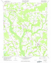
(6)- 1977 Map of Winstead Crossroads
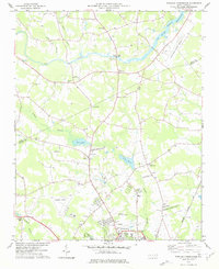 1977 Winstead Crossroads1977 Print · USGSCoastal Plain farmland and growing aviation hubs meet at the Nash and Wilson county line during the late seventies. Researchers can trace the heritage of rural communities through local landmarks like Winstead Crossroads, Finch Mill, and Tar River Sch.
 - 1977 Map of Elm City
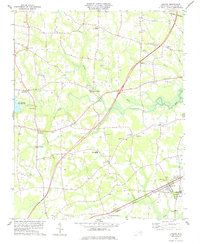
 1977 Elm City1977 Print · USGSCoastal plain agriculture and rail transport meet in the late 1970s at the junction of Nash, Wilson, and Edgecombe counties. Researchers can trace historic family landmarks and rural nodes like Elm City, Bridgersville, and Pleasant Hope Ch.
 - 1978 Map of Lucama
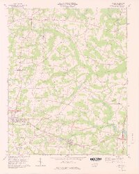
 1978 Lucama1978 Print · USGSCoastal plain farming and railroad commerce define this part of Wilson County in the late seventies. Genealogists can trace family roots through dozens of local cemeteries and churches like Nobles Chapel or explore settlements at Rock Ridge and Lucama.
 - 1978 Map of Bailey
 1978 Bailey1978 Print · USGSThe Nash and Wilson County border comes alive in the late 1970s, showing a landscape of small farming communities and swampy lowlands. You can trace family history through numerous rural cemeteries and landmark churches like Floods Chapel and Mitchells Chapel.3 unique versions available
 - 1978 Map of Saratoga
 1978 Saratoga1978 Print · USGSSaratoga and the Wilson County countryside are captured here in the late seventies, showing a landscape defined by deep swamps and rural crossroads. Genealogists and local historians can locate many family landmarks, from Drivers Store to rural congregations like Zimmerman Chapel and Barnes Chapel.
 - 1978 Map of Wilson, 1979 Print
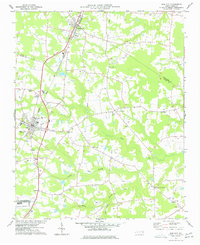
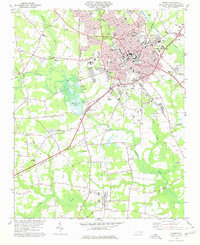 1978 Wilson1979 Print · USGSThe city of WILSON and its outlying communities are captured in the late seventies as a busy rail and institutional hub. Researchers can trace the legacy of local education and faith through sites like Atlantic Christian College, Darden High Sch, and Lower Black Creek Ch.
End of results
Showing maps 1-6 of 6
Top cities near Wilson
- Rocky Mount historical maps
- Nashville historical maps
- Sharpsburg historical maps
- Fremont historical maps
- Kenly historical maps
- Elm City historical maps
See more
Top neighborhoods of Wilson
- Lincoln Heights historical maps
- Merrimont historical maps
- Montclair historical maps
- Edgewood historical maps
- Newton Park historical maps
- Pineview Acres historical maps
See more
Frequently asked questions
- What are the different types of historical maps available for Wilson?
- What is the oldest map of Wilson?
- Where can I purchase historical maps of Wilson for my home or office?
- Where can I download high-res historical maps of Wilson?
- Are there historical topographic maps available for Wilson?
- Is there historical aerial imagery available for Wilson?
- Where are historical maps of Wilson sourced from?