1900s (20th Century) Maps of Mansfield Township, North Dakota
Explore 7 historic maps of Mansfield Township from the 1900s (20th Century). These maps offer a rare glimpse into what life looked like during the 1900s — showing old roads, neighborhoods, homes, and landmarks that have changed or disappeared over time.
Whether you're researching your family's past, planning a metal detecting trip, or studying how Mansfield Township's landscape evolved across the 1900s, these high-resolution maps are a powerful tool for exploring the history of this region.
- Focus on a specific era: All maps on this page are from the 1900s, giving you a focused view of this time period.
- See what’s changed: Compare century-old streets, trails, and buildings to today's modern landscape using overlays and satellite layers.
- Research with precision: Use these maps for genealogy, historical research, land use analysis, or educational projects.
- View, download, or print: Maps are fully viewable online in high resolution, and can be downloaded or printed for your own records.
Start exploring Mansfield Township's history through authentic maps from the 1900s. This is your window into the past.
Mansfield Township, ND maps
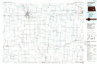
(7)- 1953 Map of Jamestown
 1953 Jamestown1953 Print · USGSSoutheastern North Dakota was a thriving rail and agricultural corridor in the early fifties, anchored by the James River. Researchers can trace the footprints of institutional landmarks like the North Dakota State Hospital and historic sites such as Whitestone Hill Battlefield Park.3 unique versions available
 - 1956 Map of Jamestown
 1956 Jamestown1956 Print · USGSThe James River valley and the vast alkali lake country of south-central North Dakota are captured here in the mid-fifties. Genealogists can trace family farms across several counties, locating small rail stops like Medberry and monuments like Whitestone Hill Battlefield Park.
 - 1970 Map of Eckelson, 1973 Print
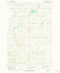
 1970 Eckelson1973 Print · USGSNorth Dakota's prairie pothole region is captured here in the early seventies, centered on the railroad town of Eckelson. Researchers can trace the legacy of the land through water features like Eckelson Lake and the industrial footprint of the Burlington Northern line.
 - 1970 Map of Spiritwood, 1973 Print
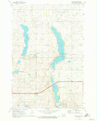
 1970 Spiritwood1973 Print · USGSThe North Dakota prairie at the start of the 1970s shows a landscape defined by the Burlington Northern railroad and large glacial lakes. Genealogists and local historians can trace the small sidings of Spiritwood and Urbana or locate family lands near Goose Lake.
 - 1970 Map of Eckelson SE, 1973 Print
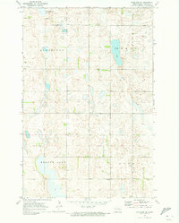 1970 Eckelson SE1973 Print · USGSSoutheastern Barnes County in the early 1970s is a landscape of glacial potholes and prairie wetlands. Local historians can trace the community's heart through the sites of Elim Ch, St Thomas Ch, and the central Townhall near Meadow Lake.
 - 1970 Map of Eckelson SW, 1973 Print
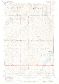
 1970 Eckelson SW1973 Print · USGSThe rural prairie border of Stutsman and Barnes counties comes into focus during the early 1970s. Researchers can trace the section lines of Winfield and Ypsilanti or locate the local Townhall and the protected Mud Lake wetlands.
 - 1986 Map of Jamestown
 1986 Jamestown1986 Print · USGSThe eastern North Dakota prairie comes into focus in the mid-eighties, centered on the rail and river hubs of Jamestown and Valley City. You can trace the Burlington Northern line through historic stops like Eckelson, Sanborn, and Spiritwood while exploring vast wildlife refuges and local landmarks.2 unique versions available
End of results
Showing maps 1-7 of 7
Top cities near Mansfield Township
- Sanborn historical maps
- Litchville historical maps
- Ypsilanti historical maps
- Adrian Township historical maps
- Montpelier historical maps
- Eckelson historical maps
See more
Frequently asked questions
- What are the different types of historical maps available for Mansfield Township?
- What is the oldest map of Mansfield Township?
- Where can I purchase historical maps of Mansfield Township for my home or office?
- Where can I download high-res historical maps of Mansfield Township?
- Are there historical topographic maps available for Mansfield Township?
- Is there historical aerial imagery available for Mansfield Township?
- Where are historical maps of Mansfield Township sourced from?