1900s (20th Century) Maps of Gorham, North Dakota
Explore 6 historic maps of Gorham from the 1900s (20th Century). These maps offer a rare glimpse into what life looked like during the 1900s — showing old roads, neighborhoods, homes, and landmarks that have changed or disappeared over time.
Whether you're researching your family's past, planning a metal detecting trip, or studying how Gorham's landscape evolved across the 1900s, these high-resolution maps are a powerful tool for exploring the history of this region.
- Focus on a specific era: All maps on this page are from the 1900s, giving you a focused view of this time period.
- See what’s changed: Compare century-old streets, trails, and buildings to today's modern landscape using overlays and satellite layers.
- Research with precision: Use these maps for genealogy, historical research, land use analysis, or educational projects.
- View, download, or print: Maps are fully viewable online in high resolution, and can be downloaded or printed for your own records.
Start exploring Gorham's history through authentic maps from the 1900s. This is your window into the past.
Gorham, ND maps
(6)- 1953 Map of Watford City, 1968 Print
 1953 Watford City1968 Print · USGSNorth Dakota's badlands and the Missouri River basin are captured here during the 1950s and 60s as the Garrison Dam changed the landscape. Researchers can trace old rail lines like the Great Northern or find rural outposts such as Grassy Butte and Halliday.3 unique versions available
 - 1957 Map of Watford City
 1957 Watford City1957 Print · USGSWestern North Dakota's landscape is captured here during the mid-fifties as the Missouri River valley undergoes massive change following the creation of Garrison Reservoir. Genealogists and historians can trace dozens of rural schools like Divide School and early settlements such as Arnegard and Grassy Butte.
 - 1963 Map of Gorham, 1964 Print
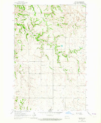 1963 Gorham1964 Print · USGSBillings County, North Dakota, is documented in the early sixties as a region of remote prairie settlements and winding creek beds. Genealogists can trace rural community life through the locations of St Jacobs Cem, Pioneer Sch No 1, and the church at Gorham.
 - 1967 Map of Watford City
 1967 Watford City1967 Print · USGSWestern North Dakota is captured during a period of landscape transformation as the Missouri River valley was reshaped by the new Garrison Reservoir. Genealogists and local historians can trace the foundations of Watford City, find the Elkhorn Ranch Site, or locate rural landmarks like Ziner Butte and Grassy Butte.
 - 1983 Map of Grassy Butte
 1983 Grassy Butte1983 Print · USGSWestern North Dakota’s Badlands are mapped here in the early 1980s, centered on the Little Missouri River and its rugged breaks. Local historians can trace the boundaries of Grassy Butte and Fairfield, alongside landmarks like Pikes Peak and the isolated Elkhorn Ranch Site.
 - 1997 Map of Gorham, 2001 Print
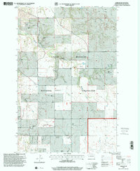 1997 Gorham2001 Print · USGSBillings County ranching country is captured here in the late nineties, showing the vast cattle-rearing landscape of the Badlands. Genealogists can trace family legacies at the Gorham settlement site, St Jacobs Cem, and the Lowman Ranch.
End of results
Showing maps 1-6 of 6
Frequently asked questions
- What are the different types of historical maps available for Gorham?
- What is the oldest map of Gorham?
- Where can I purchase historical maps of Gorham for my home or office?
- Where can I download high-res historical maps of Gorham?
- Are there historical topographic maps available for Gorham?
- Is there historical aerial imagery available for Gorham?
- Where are historical maps of Gorham sourced from?