1940s Maps of Bowbells, North Dakota
Explore 3 historic maps of Bowbells from the 1940s. These maps offer a rare glimpse into what life looked like during the 1940s — showing old roads, neighborhoods, homes, and landmarks that have changed or disappeared over time.
Whether you're researching your family's past, planning a metal detecting trip, or studying how Bowbells's landscape evolved across the 1940s, these high-resolution maps are a powerful tool for exploring the history of this region.
- Focus on a specific era: All maps on this page are from the 1940s, giving you a focused view of this time period.
- See what’s changed: Compare century-old streets, trails, and buildings to today's modern landscape using overlays and satellite layers.
- Research with precision: Use these maps for genealogy, historical research, land use analysis, or educational projects.
- View, download, or print: Maps are fully viewable online in high resolution, and can be downloaded or printed for your own records.
Start exploring Bowbells's history through authentic maps from the 1940s. This is your window into the past.
Bowbells, ND maps
(3)- 1947 Map of Bowbells, 1966 Print
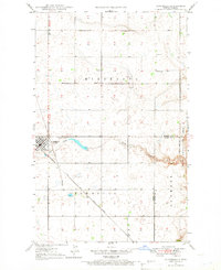 1947 Bowbells1966 Print · USGSBowbells sits at the busy junction of two major rail lines just after the war, anchoring a landscape of scattered prairie townships. Genealogists and local historians can locate Bowbells Cem, early country schools like School No 4, and the CCC Dam along Stony Creek.
 - 1948 Map of Coteau
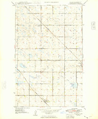 1948 Coteau1948 Print · USGSThe Burke County prairie in the late 1940s centers on the rail junction at Coteau during a period of steady rural growth. Researchers can trace local landmarks like School No 1, the Danish Cem, and a small Strip Mine near Stony Creek.
 - 1949 Map of Bowbells
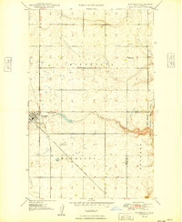 1949 Bowbells1949 Print · USGSBowbells and its surrounding townships thrive as a vital rail hub in the late 1940s. Genealogists can locate family landmarks like St Joseph Cem, School No 2, and the local Golf Course along the banks of Stony Creek.
End of results
Showing maps 1-3 of 3
Top cities near Bowbells
Frequently asked questions
- What are the different types of historical maps available for Bowbells?
- What is the oldest map of Bowbells?
- Where can I purchase historical maps of Bowbells for my home or office?
- Where can I download high-res historical maps of Bowbells?
- Are there historical topographic maps available for Bowbells?
- Is there historical aerial imagery available for Bowbells?
- Where are historical maps of Bowbells sourced from?