1980s Maps of Cavalier County, North Dakota
Explore 3 historic maps of Cavalier County from the 1980s. These maps offer a rare glimpse into what life looked like during the 1980s — showing old roads, neighborhoods, homes, and landmarks that have changed or disappeared over time.
Whether you're researching your family's past, planning a metal detecting trip, or studying how Cavalier County's landscape evolved across the 1980s, these high-resolution maps are a powerful tool for exploring the history of this region.
- Focus on a specific era: All maps on this page are from the 1980s, giving you a focused view of this time period.
- See what’s changed: Compare century-old streets, trails, and buildings to today's modern landscape using overlays and satellite layers.
- Research with precision: Use these maps for genealogy, historical research, land use analysis, or educational projects.
- View, download, or print: Maps are fully viewable online in high resolution, and can be downloaded or printed for your own records.
Start exploring Cavalier County's history through authentic maps from the 1980s. This is your window into the past.
Cavalier County, ND maps
(3)- 1985 Map of Langdon
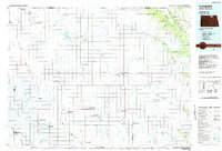 1985 Langdon1985 Print · USGSCavalier County and the surrounding prairie are captured here in the mid-1980s as the rail-and-agriculture economy shaped the landscape. Researchers can trace rural lineages through dozens of small settlements like Munich, Nekoma, and Osnabrock, or follow the lines of the Burlington Northern and Soo Line railroads.2 unique versions available
 - 1985 Map of Cavalier
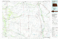 1985 Cavalier1985 Print · USGSThe Red River Valley and the international border meet in this mid-1980s look at the drainage and rail networks of Northeast North Dakota. Trace the paths of the Burlington Northern and Soo Line through border towns like Neche, Pembina, and Noyes.2 unique versions available
 - 1985 Map of Rock Lake, 1986 Print
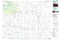 1985 Rock Lake1986 Print · USGSThe North Dakota borderlands and the forested heights of the Turtle Mountains are documented here in the mid-eighties. Genealogists and historians can trace the rail lines of the Soo Line through prairie towns like Bisbee, Rolette, and Rolla.2 unique versions available
End of results
Showing maps 1-3 of 3
Top cities of Cavalier County
- Langdon historical maps
- Munich historical maps
- Osnabrock historical maps
- Milton historical maps
- Mount Carmel historical maps
- Alsen historical maps
See more
Frequently asked questions
- What are the different types of historical maps available for Cavalier County?
- What is the oldest map of Cavalier County?
- Where can I purchase historical maps of Cavalier County for my home or office?
- Where can I download high-res historical maps of Cavalier County?
- Are there historical topographic maps available for Cavalier County?
- Is there historical aerial imagery available for Cavalier County?
- Where are historical maps of Cavalier County sourced from?