1970s Maps of Hirschville, North Dakota
Explore 2 historic maps of Hirschville from the 1970s. These maps offer a rare glimpse into what life looked like during the 1970s — showing old roads, neighborhoods, homes, and landmarks that have changed or disappeared over time.
Whether you're researching your family's past, planning a metal detecting trip, or studying how Hirschville's landscape evolved across the 1970s, these high-resolution maps are a powerful tool for exploring the history of this region.
- Focus on a specific era: All maps on this page are from the 1970s, giving you a focused view of this time period.
- See what’s changed: Compare century-old streets, trails, and buildings to today's modern landscape using overlays and satellite layers.
- Research with precision: Use these maps for genealogy, historical research, land use analysis, or educational projects.
- View, download, or print: Maps are fully viewable online in high resolution, and can be downloaded or printed for your own records.
Start exploring Hirschville's history through authentic maps from the 1970s. This is your window into the past.
Hirschville, ND maps
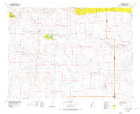
(2)- 1973 Map of Hirschville, 1977 Print
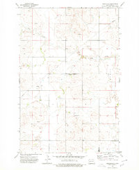 1973 Hirschville1977 Print · USGSDunn and Stark counties appear here in the early 1970s, showcasing a landscape of prairie draws and small-scale settlement. Researchers can locate the community of Hirschville and trace the influence of water on the land through features like Deep Creek and the Flowing Well.
 - 1974 Map of Killdeer, 1976 Print
 1974 Killdeer1976 Print · USGSWestern North Dakota's ranching and rail country comes into focus in the mid-seventies, showing the prairie landscape before modern energy booms. Trace the Burlington Northern line through Dodge, Werner, and Golden Valley, or locate family landmarks near Manning and New Hradec.
End of results
Showing maps 1-2 of 2
Top cities near Hirschville
Frequently asked questions
- What are the different types of historical maps available for Hirschville?
- What is the oldest map of Hirschville?
- Where can I purchase historical maps of Hirschville for my home or office?
- Where can I download high-res historical maps of Hirschville?
- Are there historical topographic maps available for Hirschville?
- Is there historical aerial imagery available for Hirschville?
- Where are historical maps of Hirschville sourced from?