1890s Maps of Roscoe Township, North Dakota
Explore 5 historic maps of Roscoe Township from the 1890s. These maps offer a rare glimpse into what life looked like during the 1890s — showing old roads, neighborhoods, homes, and landmarks that have changed or disappeared over time.
Whether you're researching your family's past, planning a metal detecting trip, or studying how Roscoe Township's landscape evolved across the 1890s, these high-resolution maps are a powerful tool for exploring the history of this region.
- Focus on a specific era: All maps on this page are from the 1890s, giving you a focused view of this time period.
- See what’s changed: Compare century-old streets, trails, and buildings to today's modern landscape using overlays and satellite layers.
- Research with precision: Use these maps for genealogy, historical research, land use analysis, or educational projects.
- View, download, or print: Maps are fully viewable online in high resolution, and can be downloaded or printed for your own records.
Start exploring Roscoe Township's history through authentic maps from the 1890s. This is your window into the past.
Roscoe Township, ND maps
(5)- 1894 Map of La Moure
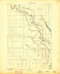 1894 La Moure1894 Print · USGSSoutheastern North Dakota's prairie landscape is captured here during the railroad boom of the late nineteenth century. Trace the early development of Lamoure and Grand Rapids along the James River and the converging tracks of the Northern Pacific Railroad.
 - 1895 Map of Lamoure
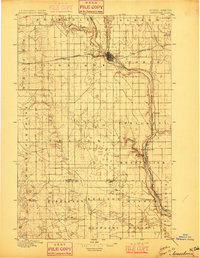
 1895 Lamoure1895 Print · USGSSoutheastern North Dakota was a landscape of rapid rail expansion and river-based settlement in the mid-1890s. Genealogists and historians can trace the early foundations of towns like Lamoure, Oakes, and Grand Rapids along the winding James River.2 unique versions available
 - 1896 Map of Jamestown
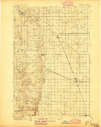
 1896 Jamestown1896 Print · USGSJamestown and the surrounding prairie were rapidly developing at the close of the nineteenth century as the railroad transformed the territory. Genealogists and historians can trace the early rail stops and river settlements like Eldridge, Ypsilanti, and Adrian.3 unique versions available
 - 1896 Map of Edgeley
 1896 Edgeley1896 Print · USGSDakota Territory had only recently achieved statehood when these rail lines began carving through the prairie. Genealogists can trace the early foundations of Edgeley, Kulm, and Ellendale alongside rural townships like Whitestone and Glenmore.2 unique versions available
 - 1897 Map of Eckelson
 1897 Eckelson1897 Print · USGSEastern North Dakota in the late nineteenth century was a land defined by the iron rail and a network of glacial lakes. Genealogists can trace early homesteads and rail stops near Valley City, Sanborn, and the isolated post office at Svea.3 unique versions available
End of results
Showing maps 1-5 of 5
Top cities near Roscoe Township
- LaMoure historical maps
- Marion historical maps
- Adrian Township historical maps
- Montpelier historical maps
- Grand Rapids historical maps
- Dickey historical maps
See more
Frequently asked questions
- What are the different types of historical maps available for Roscoe Township?
- What is the oldest map of Roscoe Township?
- Where can I purchase historical maps of Roscoe Township for my home or office?
- Where can I download high-res historical maps of Roscoe Township?
- Are there historical topographic maps available for Roscoe Township?
- Is there historical aerial imagery available for Roscoe Township?
- Where are historical maps of Roscoe Township sourced from?