1900s (20th Century) Maps of Garrison, North Dakota
Explore 5 historic maps of Garrison from the 1900s (20th Century). These maps offer a rare glimpse into what life looked like during the 1900s — showing old roads, neighborhoods, homes, and landmarks that have changed or disappeared over time.
Whether you're researching your family's past, planning a metal detecting trip, or studying how Garrison's landscape evolved across the 1900s, these high-resolution maps are a powerful tool for exploring the history of this region.
- Focus on a specific era: All maps on this page are from the 1900s, giving you a focused view of this time period.
- See what’s changed: Compare century-old streets, trails, and buildings to today's modern landscape using overlays and satellite layers.
- Research with precision: Use these maps for genealogy, historical research, land use analysis, or educational projects.
- View, download, or print: Maps are fully viewable online in high resolution, and can be downloaded or printed for your own records.
Start exploring Garrison's history through authentic maps from the 1900s. This is your window into the past.
Garrison, ND maps
(5)- 1922 Map of Garrison
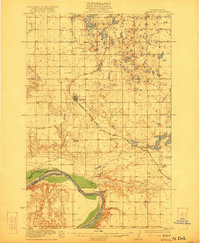 1922 Garrison1922 Print · USGSIn the early 1920s, McLean County was a landscape of steam-powered transit and scattered prairie schoolhouses. Researchers can trace the original Soo Line rail corridor and locate rural landmarks like Ireland School, Baker School, and the winding Snake Creek valley.2 unique versions available
 - 1954 Map of McClusky, 1968 Print
 1954 McClusky1968 Print · USGSCentral North Dakota was undergoing a profound transformation in the fifties as the newly formed Lake Sakakawea reshaped the Missouri River valley. Genealogists and historians can trace rail-town development along the Soo Line and locate historic markers like Garrison Dam or the Lewis and Clark Trail.3 unique versions available
 - 1958 Map of McClusky
 1958 McClusky1958 Print · USGSCentral North Dakota was undergoing a profound change in the late fifties as the Garrison Reservoir filled behind its massive new dam. Trace the early layout of Riverdale, the Lewis and Clark Trail, and the vanishing rail stops of the Northern Pacific.
 - 1974 Map of Garrison NW, 1975 Print
 1974 Garrison NW1975 Print · USGSThe prairie landscape surrounding Garrison is captured in the mid-seventies, revealing the fine details of North Dakota's agricultural heartland. Genealogists and local historians can trace farmstead footprints and the early shoreline of Lake Sakakawea.
 - 1981 Map of Garrison, 1982 Print
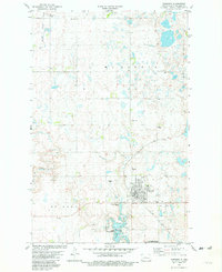 1981 Garrison1982 Print · USGSGarrison stands at the edge of the Missouri River reservoir system during the early eighties, showing the town's expansion and its rail connections. Genealogists and historians can locate St Nicholas Cem, trace the Soo Line, and see the shoreline of Lake Sakakawea.
End of results
Showing maps 1-5 of 5
Top cities near Garrison
- Riverdale historical maps
- Max historical maps
- Pick City historical maps
- Coleharbor historical maps
- Douglas historical maps
Frequently asked questions
- What are the different types of historical maps available for Garrison?
- What is the oldest map of Garrison?
- Where can I purchase historical maps of Garrison for my home or office?
- Where can I download high-res historical maps of Garrison?
- Are there historical topographic maps available for Garrison?
- Is there historical aerial imagery available for Garrison?
- Where are historical maps of Garrison sourced from?