1980s Maps of Nelson County, North Dakota
Explore 4 historic maps of Nelson County from the 1980s. These maps offer a rare glimpse into what life looked like during the 1980s — showing old roads, neighborhoods, homes, and landmarks that have changed or disappeared over time.
Whether you're researching your family's past, planning a metal detecting trip, or studying how Nelson County's landscape evolved across the 1980s, these high-resolution maps are a powerful tool for exploring the history of this region.
- Focus on a specific era: All maps on this page are from the 1980s, giving you a focused view of this time period.
- See what’s changed: Compare century-old streets, trails, and buildings to today's modern landscape using overlays and satellite layers.
- Research with precision: Use these maps for genealogy, historical research, land use analysis, or educational projects.
- View, download, or print: Maps are fully viewable online in high resolution, and can be downloaded or printed for your own records.
Start exploring Nelson County's history through authentic maps from the 1980s. This is your window into the past.
Nelson County, ND maps
(4)- 1985 Map of Grafton
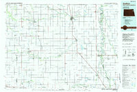 1985 Grafton1985 Print · USGSThe Red River Valley at the mid-eighties shows a landscape of deep-rooted agriculture and rail-side towns. Genealogists and historians can trace family land near Grafton, Minto, or Lankin, and locate conservation landmarks like the Ardoch National Wildlife Refuge.2 unique versions available
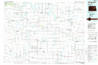
 - 1985 Map of Devils Lake
 1985 Devils Lake1985 Print · USGSThe Ramsey County lake region is captured here in the mid-1980s as a vital hub of wildlife management and grain transport. Researchers can trace the sprawling boundaries of the Fort Totten Indian Reservation and locate local landmarks like Lake Region Jr College and Whitman Dam.
 - 1985 Map of Stump Lake
 1985 Stump Lake1985 Print · USGSNorth Dakota's lake country in the mid-eighties shows a landscape shaped by the Burlington Northern rail line and tribal lands. Genealogists and historians can locate family sites near Warwick, Tokio, and the Fort Totten Indian Reservation.2 unique versions available
 - 1985 Map of Grand Forks
 1985 Grand Forks1985 Print · USGSThe Red River Valley in the mid-1980s was a landscape of deep-rooted agriculture and rising military significance. Genealogists and researchers can trace the rail-tied development of towns like Larimore and Northwood alongside major landmarks like Grand Forks Air Force Base and Turtle River State Park.2 unique versions available
End of results
Showing maps 1-4 of 4
Top cities of Nelson County
- Lakota historical maps
- McVille historical maps
- Michigan City historical maps
- Aneta historical maps
- Tolna historical maps
- Petersburg historical maps
See more
Frequently asked questions
- What are the different types of historical maps available for Nelson County?
- What is the oldest map of Nelson County?
- Where can I purchase historical maps of Nelson County for my home or office?
- Where can I download high-res historical maps of Nelson County?
- Are there historical topographic maps available for Nelson County?
- Is there historical aerial imagery available for Nelson County?
- Where are historical maps of Nelson County sourced from?