1970s Maps of Nelson County, North Dakota
Explore 15 historic maps of Nelson County from the 1970s. These maps offer a rare glimpse into what life looked like during the 1970s — showing old roads, neighborhoods, homes, and landmarks that have changed or disappeared over time.
Whether you're researching your family's past, planning a metal detecting trip, or studying how Nelson County's landscape evolved across the 1970s, these high-resolution maps are a powerful tool for exploring the history of this region.
- Focus on a specific era: All maps on this page are from the 1970s, giving you a focused view of this time period.
- See what’s changed: Compare century-old streets, trails, and buildings to today's modern landscape using overlays and satellite layers.
- Research with precision: Use these maps for genealogy, historical research, land use analysis, or educational projects.
- View, download, or print: Maps are fully viewable online in high resolution, and can be downloaded or printed for your own records.
Start exploring Nelson County's history through authentic maps from the 1970s. This is your window into the past.
Nelson County, ND maps
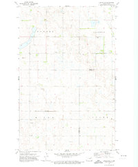
(15)- 1970 Map of Lakota, 1972 Print
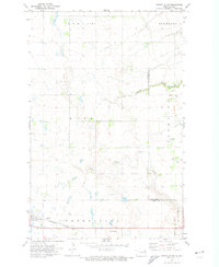
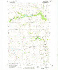
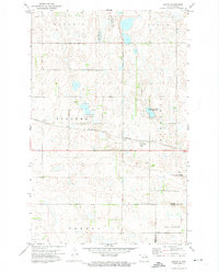
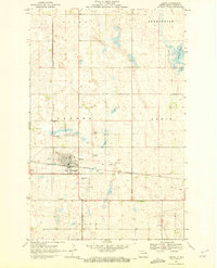 1970 Lakota1972 Print · USGSThe Nelson County seat of Lakota is shown here during the early 1970s, as the railway and highway network supported a growing prairie hub. Researchers can trace the town's footprint including the Lakota center, the Cem, and the Golf Course.2 unique versions available
 - 1970 Map of Bartlett, 1972 Print
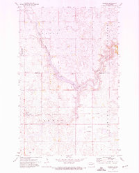
 1970 Bartlett1972 Print · USGSThe North Dakota prairie near the Ramsey and Nelson county line is captured here during the transition to the 1970s. Researchers can locate the town of Bartlett along the Burlington Northern tracks and trace the boundaries of the Rose Lake National Wildlife Refuge.
 - 1971 Map of Michigan West, 1974 Print
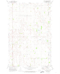
 1971 Michigan West1974 Print · USGSNelson County prairie life centered on the rail corridor in the early 1970s, as small towns navigated a landscape of glacial lakes. Genealogists can trace property lines across Enterprise and Williams townships or locate family sites near Mapes and Michigan City.2 unique versions available
 - 1971 Map of Michigan East, 1974 Print
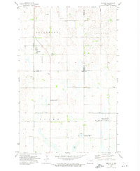
 1971 Michigan East1974 Print · USGSNelson County at the start of the 1970s shows a landscape of rail-connected towns and protected wetlands. Trace the Northern rail line between Michigan and Petersburg or find family roots at the Michigan Cem.
 - 1971 Map of Fordville SW, 1974 Print
 1971 Fordville SW1974 Print · USGSNelson and Grand Forks counties appear here in the early 1970s, showing a prairie landscape defined by the Burlington Northern rail line. Researchers can trace the layout of Petersburg, find the St Andrews Cem, and follow the winding path of Skunk Coulee.
 - 1971 Map of Whitman, 1974 Print
 1971 Whitman1974 Print · USGSThe small prairie settlement of Whitman and its surrounding townships appear here in the early 1970s, just as modern conservation efforts took hold along the Middle Branch Forest River. You can trace the path of the Soo Line railroad and locate local landmarks like the East Sarnia Cem and Whitman Dam.
 - 1971 Map of Lake Pickard, 1974 Print
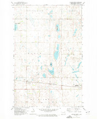
 1971 Lake Pickard1974 Print · USGSThe borderlands of Nelson and Grand Forks counties come into focus during the early seventies, showing a landscape defined by prairie water and rural townships. Genealogists and local historians can locate Lom Ch, the local Townhall, and the winding Goose River.
 - 1971 Map of Brocket, 1974 Print
 1971 Brocket1974 Print · USGSBrocket and the surrounding prairie townships are captured here in the early 1970s, showcasing a landscape of rail-fed settlements and conservation lands. Trace local family history through sites like Vaage Cem, the Finnish Ch, and the Soo Line tracks.
 - 1971 Map of Dahlen, 1974 Print
 1971 Dahlen1974 Print · USGSDahlen and the surrounding prairie townships are captured here in the early seventies as the agricultural landscape matured. Genealogists can locate family landmarks like Quale Ch, Zion Cem, and the path of the Soo Line railroad.
 - 1971 Map of New Rockford, 1974 Print
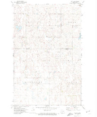
 1971 New Rockford1974 Print · USGSCentral North Dakota was a landscape of wildlife refuges and rail-linked agricultural towns in the early seventies. Genealogists and local historians can trace the development of the Fort Totten Indian Reservation and locate old railway points like Maddock, Hamal, and Kloten.
 - 1971 Map of Lambs Lake, 1974 Print
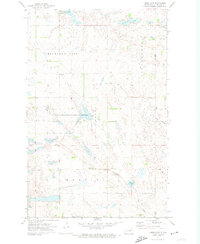 1971 Lambs Lake1974 Print · USGSNelson County's prairie wetland landscape is documented here in the early 1970s, showing a region dedicated to agriculture and conservation. Genealogists and local historians can locate the Melrose Ch Cem, the township Townhall, and the expansive Lambs Lake National Wildlife Refuge.
 - 1971 Map of Pelto, 1974 Print
 1971 Pelto1974 Print · USGSNelson and Walsh Counties are shown in the early seventies, capturing the quiet agricultural character of the North Dakota prairie. Researchers can locate the railroad settlement of Pelto, the Finnish Cem, and the path of the SOO LINE.
 - 1971 Map of Bitter Lake, 1974 Print
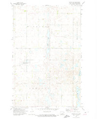 1971 Bitter Lake1974 Print · USGSNelson County's prairie pothole landscape is preserved in the early seventies, showing a network of wetlands and rural townships. Researchers can trace the boundaries of the National Waterfowl Production Area and locate local landmarks like Bitter Lake and Horseshoe Lake.
 - 1971 Map of Doyon, 1974 Print
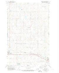
 1971 Doyon1974 Print · USGSRamsey County and the surrounding prairie are captured here in the early 1970s as the rail and conservation systems matured. Trace the layout of Doyon, locate the Doyon Cem, and follow the Burlington Northern line across the township grid.
 - 1971 Map of Lakota NW, 1974 Print
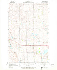
 1971 Lakota NW1974 Print · USGSNorthern Ramsey County and Nelson County are captured here in the early seventies, showing a quiet landscape of prairie townships and rail. Genealogists and local historians can locate Hope Cem or trace the Soo Line railroad through Nixon and Clara.
End of results
Showing maps 1-15 of 15
Top cities of Nelson County
- Lakota historical maps
- McVille historical maps
- Michigan City historical maps
- Aneta historical maps
- Tolna historical maps
- Petersburg historical maps
See more
Frequently asked questions
- What are the different types of historical maps available for Nelson County?
- What is the oldest map of Nelson County?
- Where can I purchase historical maps of Nelson County for my home or office?
- Where can I download high-res historical maps of Nelson County?
- Are there historical topographic maps available for Nelson County?
- Is there historical aerial imagery available for Nelson County?
- Where are historical maps of Nelson County sourced from?