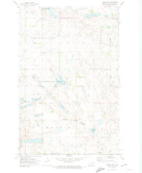
1971 Map of Lambs Lake
USGS Topo · Published 1974About this map
Lambs Lake National Wildlife Refuge and the National Waterfowl Production Area define this pocket of Nelson County, where the prairie landscape is dotted with numerous kettle lakes and wetlands. The map illustrates a rural society organized around townships such as Michigan City, Petersburg, and Melvin, where the section lines of the Public Land Survey System dictate the placement of roads and farmsteads. Local history is anchored by landmarks like the Townhall and the Melrose Ch Cem, while the winding course of Goose Creek connects larger water bodies like Stella Lake and Harrison Lake. The abundance of named Gravel Pits throughout the quadrangle points to the importance of local material extraction for maintaining the area's grid-based transport network.
Find a feature on this map
16 named features on this map. Tap any name to fly to it.
Don’t see what you’re looking for? This feature index may not catch every label — zoom into the map to look around manually.
Map Details
Editions of this 1971 Lambs Lake Map
This is the sole edition of this map. No revisions or reprints were ever made.
Other maps of this area

1939 · Niagara
USGS Topo · 1:62,500

1942 · McVille
USGS Topo · 1:62,500

1952 · Grand Forks
USGS Topo · 1:250,000

1952 · Thief River Falls
USGS Topo · 1:250,000

1952 · New Rockford
USGS Topo · 1:250,000

1953 · Devils Lake
USGS Topo · 1:250,000

1956 · New Rockford
USGS Topo · 1:250,000

1956 · Thief River Falls
USGS Topo · 1:250,000

1956 · Devils Lake
USGS Topo · 1:250,000

1956 · Grand Forks
USGS Topo · 1:250,000