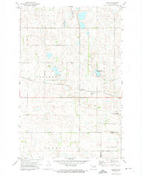
1971 Map of Doyon
USGS Topo · Published 1974About this map
Doyon serves as the central hub of this prairie landscape during the early 1970s, situated at the intersection of local township life and major transportation lines. The Burlington Northern railroad bisects the terrain, running east-to-west through the heart of the settlement. The map reveals the intricate land management of the era, where the rural townships of Stevens, Bartlett, Odessa, and Illinois meet near the Ramsey Co Nelson Co line. Numerous depressions and wetlands are designated as the National Waterfowl Production Area, highlighting the conservation priorities of the time amidst an agricultural backdrop. Genealogists will find interest in the precisely located Doyon Cem, while several Gravel Pit operations indicate the local industry supporting the region's road and rail infrastructure.
Find a feature on this map
13 named features on this map. Tap any name to fly to it.
Don’t see what you’re looking for? This feature index may not catch every label — zoom into the map to look around manually.
Map Details
Editions of this 1971 Doyon Map
This is the sole edition of this map. No revisions or reprints were ever made.
Other maps of this area

1930 · Pekin
USGS Topo · 1:62,500

1930 · Hamar
USGS Topo · 1:62,500

1950 · Devils Lake Mountain
USGS Topo · 1:24,000

1951 · Crary
USGS Topo · 1:24,000

1951 · Devils Lake Mountain
USGS Topo · 1:24,000

1951 · Pekin NW
USGS Topo · 1:24,000

1951 · Free Peoples Lake
USGS Topo · 1:24,000

1951 · Pekin
USGS Topo · 1:62,500

1952 · New Rockford
USGS Topo · 1:250,000

1953 · Devils Lake
USGS Topo · 1:250,000