1960s Maps of Owego Township, North Dakota
Explore 4 historic maps of Owego Township from the 1960s. These maps offer a rare glimpse into what life looked like during the 1960s — showing old roads, neighborhoods, homes, and landmarks that have changed or disappeared over time.
Whether you're researching your family's past, planning a metal detecting trip, or studying how Owego Township's landscape evolved across the 1960s, these high-resolution maps are a powerful tool for exploring the history of this region.
- Focus on a specific era: All maps on this page are from the 1960s, giving you a focused view of this time period.
- See what’s changed: Compare century-old streets, trails, and buildings to today's modern landscape using overlays and satellite layers.
- Research with precision: Use these maps for genealogy, historical research, land use analysis, or educational projects.
- View, download, or print: Maps are fully viewable online in high resolution, and can be downloaded or printed for your own records.
Start exploring Owego Township's history through authentic maps from the 1960s. This is your window into the past.
Owego Township, ND maps
(4)- 1960 Map of Coburn, 1962 Print
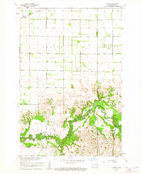 1960 Coburn1962 Print · USGSRansom County's prairie and river-valley landscape are captured here during the early sixties, showing the agricultural patterns of the Great Plains. Researchers can locate family landmarks like the Owego Ch, the Northern Pacific rail line, and the Vivasaker Bridge crossing.
 - 1960 Map of Venlo, 1962 Print
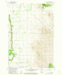 1960 Venlo1962 Print · USGSRansom County in the early sixties is captured here as the Soo Line railroad serves the small prairie siding of Venlo. Researchers can trace the winding Sheyenne River to Heaton Bridge or locate several artesian Flowing Wells in the southern townships.
 - 1960 Map of Sheldon, 1962 Print
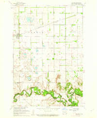 1960 Sheldon1962 Print · USGSRansom County in the early sixties shows a landscape of steady prairie farming and river-valley transport. Genealogists and historians can trace the Northern Pacific rail line through Sheldon or locate river crossings like McClellan Bridge and Larson Bridge.
 - 1961 Map of McLeod, 1964 Print
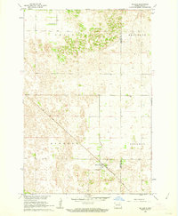 1961 McLeod1964 Print · USGSThe eastern North Dakota prairie is captured here in the early sixties, centered on the railroad hub of McLeod. Researchers can trace the path of the Soo Line and locate the Free Lutheran Cem near the borders of Sheyenne and Owego.
End of results
Showing maps 1-4 of 4
Top cities near Owego Township
- Enderlin historical maps
- Leonard historical maps
- Barrie Township historical maps
- Sheldon historical maps
- Coburn Township historical maps
Frequently asked questions
- What are the different types of historical maps available for Owego Township?
- What is the oldest map of Owego Township?
- Where can I purchase historical maps of Owego Township for my home or office?
- Where can I download high-res historical maps of Owego Township?
- Are there historical topographic maps available for Owego Township?
- Is there historical aerial imagery available for Owego Township?
- Where are historical maps of Owego Township sourced from?