1970s Maps of Steele County, North Dakota
Explore 6 historic maps of Steele County from the 1970s. These maps offer a rare glimpse into what life looked like during the 1970s — showing old roads, neighborhoods, homes, and landmarks that have changed or disappeared over time.
Whether you're researching your family's past, planning a metal detecting trip, or studying how Steele County's landscape evolved across the 1970s, these high-resolution maps are a powerful tool for exploring the history of this region.
- Focus on a specific era: All maps on this page are from the 1970s, giving you a focused view of this time period.
- See what’s changed: Compare century-old streets, trails, and buildings to today's modern landscape using overlays and satellite layers.
- Research with precision: Use these maps for genealogy, historical research, land use analysis, or educational projects.
- View, download, or print: Maps are fully viewable online in high resolution, and can be downloaded or printed for your own records.
Start exploring Steele County's history through authentic maps from the 1970s. This is your window into the past.
Steele County, ND maps
(6)- 1970 Map of Northwood SE, 1972 Print
 1970 Northwood SE1972 Print · USGSSteele County's rural townships were characterized by sprawling grain farms and quiet community centers in the 1970s. Researchers can pinpoint early landmarks like Little Forks Ch, the Townhall, and family burial sites including Stevens Memorial Cem.
 - 1970 Map of Hatton, 1972 Print
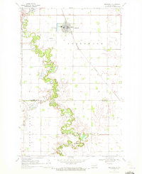
 1970 Hatton1972 Print · USGSHatton and the surrounding prairie townships are captured here in the early 1970s at the intersection of Traill, Grand Forks, and Steele counties. Genealogists can locate family landmarks like St Johns Cem, Zoar Cem, and the rural Washington Prairie Ch.
 - 1970 Map of Northwood NW, 1972 Print
 1970 Northwood NW1972 Print · USGSThe Grand Forks and Steele county line is defined by quiet prairie drainages and social centers like Bethania Ch in the early seventies. Genealogists can trace family roots through the Herickson Cem, Hanson Cem, and community Townhall locations.
 - 1970 Map of Northwood, 1972 Print
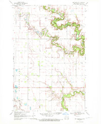
 1970 Northwood1972 Print · USGSNorthwood and the surrounding prairie are captured here in the early 1970s, as the Burlington Northern rail line cuts across the fertile valley. Genealogists and researchers can trace the winding Goose River, locate the Lutheran Cem, and find the Vince Landing Strip north of the county line.
 - 1970 Map of Golden Lake, 1972 Print
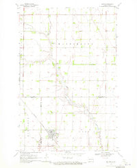
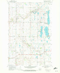 1970 Golden Lake1972 Print · USGSSteele County, North Dakota, is captured here in the early 1970s as a landscape of prairie potholes and winding creeks. Genealogists and local historians can locate family landmarks such as Beaver Creek Church, Bethany Church, and a rural Cemetery.
 - 1970 Map of Hatton SW, 1972 Print
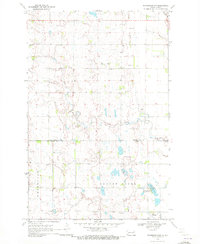
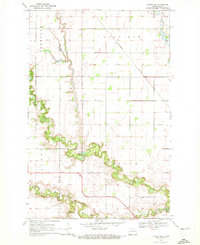 1970 Hatton SW1972 Print · USGSPortland and the surrounding townships were captured in the early 1970s at the confluence of the Goose River branches. Genealogists and local historians can trace the paths of the Burlington Northern railroad or locate family sites near Aurdal Cem and River Park.
End of results
Showing maps 1-6 of 6
Top cities of Steele County
- Finley historical maps
- Hope historical maps
- Sharon historical maps
- Colgate Township historical maps
- Sherbrooke Township historical maps
- Luverne historical maps
Frequently asked questions
- What are the different types of historical maps available for Steele County?
- What is the oldest map of Steele County?
- Where can I purchase historical maps of Steele County for my home or office?
- Where can I download high-res historical maps of Steele County?
- Are there historical topographic maps available for Steele County?
- Is there historical aerial imagery available for Steele County?
- Where are historical maps of Steele County sourced from?