1900-1909 Maps of Buchanan, North Dakota
Explore 2 historic maps of Buchanan from 1900-1909. These maps offer a rare glimpse into what life looked like during the 1900s — showing old roads, neighborhoods, homes, and landmarks that have changed or disappeared over time.
Whether you're researching your family's past, planning a metal detecting trip, or studying how Buchanan's landscape evolved across the 1900s, these high-resolution maps are a powerful tool for exploring the history of this region.
- Focus on a specific era: All maps on this page are from the 1900s, giving you a focused view of this time period.
- See what’s changed: Compare century-old streets, trails, and buildings to today's modern landscape using overlays and satellite layers.
- Research with precision: Use these maps for genealogy, historical research, land use analysis, or educational projects.
- View, download, or print: Maps are fully viewable online in high resolution, and can be downloaded or printed for your own records.
Start exploring Buchanan's history through authentic maps from the 1900s. This is your window into the past.
Buchanan, ND maps
(2)- 1900 Map of Pingree
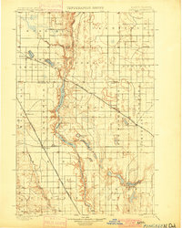 1900 Pingree1900 Print · USGSStutsman and Foster counties come alive in the final years of the nineteenth century as railroads began to stitch together the vast prairie. Researchers can trace the early rail stops at Pingree, Kensal, and Buchanan alongside the waters of Jim Lake and Spiritwood Lake.2 unique versions available
 - 1900 Map of Pingree, 1949 Print
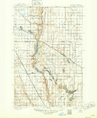 1900 Pingree1949 Print · USGSNorth Dakota's prairie landscape was being rapidly transformed by rail and river at the end of the 19th century. Researchers can trace early township development and rail stops like Pingree, Kensal, and Buchanan along the James River and Arrowwood Lake.
End of results
Showing maps 1-2 of 2
Top cities near Buchanan
- Jamestown historical maps
- Bloom historical maps
- Homer historical maps
- Fried historical maps
- Eldridge historical maps
- Spiritwood Lake historical maps
See more
Frequently asked questions
- What are the different types of historical maps available for Buchanan?
- What is the oldest map of Buchanan?
- Where can I purchase historical maps of Buchanan for my home or office?
- Where can I download high-res historical maps of Buchanan?
- Are there historical topographic maps available for Buchanan?
- Is there historical aerial imagery available for Buchanan?
- Where are historical maps of Buchanan sourced from?