
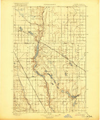
1900 Map of Pingree
USGS Topo · Published 1900About this map
The James River valley serves as the central artery for this late-19th-century landscape, carving a deep path through the prairie where a string of interconnected water bodies like Arrowwood Lake, Jim Lake, and Mud Lake form a complex riparian system. Two major rail lines define the settlement patterns of the era: the Minneapolis St. Paul & Sault Ste. Marie R. R. cuts diagonally through the northeast, supporting towns such as Kensal and Courtenay, while the Northern Pacific R. R. and its Devils Lake Branch anchor the western corridor through Pingree. These railroads were the lifelines for early agricultural outposts like Buchanan, Edmunds, and the now-obscure Esler. The map also reveals numerous small, name-associated prairie lakes including Lake George and Alkali Lake, reflecting the post-glacial hydrology of the eastern Dakotas before modern drainage and intensive land management altered the surface water profile.
Find a feature on this map
38 named features on this map. Tap any name to fly to it.
Don’t see what you’re looking for? This feature index may not catch every label — zoom into the map to look around manually.
Map Details
Editions of this 1900 Pingree Map
2 editions found
Other maps of this area

1896 · Jamestown
USGS Topo · 1:125,000

1897 · Eckelson
USGS Topo · 1:125,000

1900 · Pingree
USGS Topo · 1:62,500

1944 · Brantford
USGS Topo · 1:62,500

1946 · Brantford
USGS Topo · 1:62,500

1948 · New Rockford
USGS Topo · 1:62,500

1948 · Carrington
USGS Topo · 1:62,500

1949 · Grace City
USGS Topo · 1:24,000

1950 · Carrington East
USGS Topo · 1:24,000

1950 · Melville
USGS Topo · 1:24,000