
1949 Map of Grace City
USGS Topo · Published 1977About this map
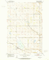
Grace City sits at a strategic bend where the Great Northern railroad crosses the James River, serving as a central hub for the surrounding townships of Columbia and Larrabee. This 1940s landscape is defined by the transition from the high ground of the Melby Hills to the water-rich depressions of the prairie, including Rusten Slough, Blue Cloud Lake, and Juanita Lake. The placement of the Grace City Cem and the Lutheran Cem near the town center provides clear points of interest for genealogists tracing early families in Foster and Eddy counties. Industrial activity is represented by a Gravel Pit along the riverbanks, reflecting the local extraction needs of the mid-century period. The map illustrates a settled agricultural grid, where the rail line and river systems dictate the placement of community infrastructure and homestead access.
Find a feature on this map
14 named features on this map. Tap any name to fly to it.
Don’t see what you’re looking for? This feature index may not catch every label — zoom into the map to look around manually.
Map Details
Editions of this 1949 Grace City Map
This is the sole edition of this map. No revisions or reprints were ever made.
Other maps of this area

1900 · Pingree
USGS Topo · 1:125,000

1944 · Brantford
USGS Topo · 1:62,500

1946 · Brantford
USGS Topo · 1:62,500

1950 · Brantford NW
USGS Topo · 1:24,000

1950 · Grace City
USGS Topo · 1:24,000

1950 · Brantford
USGS Topo · 1:24,000

1950 · Brantford NE
USGS Topo · 1:24,000

1951 · Bordulac NE
USGS Topo · 1:24,000

1951 · Kensal NW
USGS Topo · 1:24,000
1951 · Bordulac
USGS Topo · 1:24,000