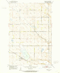
1951 Map of Bordulac
USGS Topo · Published 1953About this map
Bordulac stands as the primary rail hub on this prairie landscape, situated where the Minneapolis St Paul and Sault Ste Marie railroad cuts across the southern plains. This 1951 survey details a quintessential North Dakota township structure, defined by a grid of rural schools including School No 1, School No 3, and School No 4 that once served the farmsteads of Rose Hill and Bucephalia. The topography is shaped by the meandering path of Kelly Creek as it winds toward the basin of Lake George.
Find a feature on this map
13 named features on this map. Tap any name to fly to it.
Don’t see what you’re looking for? This feature index may not catch every label — zoom into the map to look around manually.
Map Details
Editions of this 1951 Bordulac Map
This is the sole edition of this map. No revisions or reprints were ever made.
Other maps of this area

1900 · Pingree
USGS Topo · 1:125,000

1944 · Brantford
USGS Topo · 1:62,500

1946 · Brantford
USGS Topo · 1:62,500

1948 · New Rockford
USGS Topo · 1:62,500

1948 · Carrington
USGS Topo · 1:62,500

1949 · Grace City
USGS Topo · 1:24,000

1950 · Carrington East
USGS Topo · 1:24,000

1950 · Melville
USGS Topo · 1:24,000

1950 · Grace City
USGS Topo · 1:24,000

1950 · Brantford
USGS Topo · 1:24,000