1948 Map of Carrington
USGS Topo · Published 1948About this map
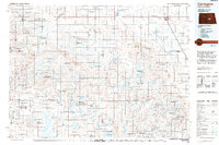
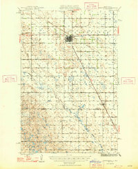
Carrington serves as the central hub of this post-war North Dakota landscape, situated at the busy junction of the Northern Pacific and the Minneapolis, St Paul, and Sault Ste Marie railroads. The map reveals a highly organized rural infrastructure, where township boundaries like Wyard, Melville, and Glacier are dotted with a systematic network of numbered country schools. While the town center shows a developing Airport, the surrounding terrain is defined by the winding course of Pipestem Creek and a dense pattern of prairie potholes and wetlands. This survey, published by the U.S. Geological Survey in cooperation with the State of North Dakota Water Conservation Commission under Chairman Fred G. Aandahl, captures the region just as modern water management and agricultural stabilization became primary local concerns. Researchers can trace the exact locations of numerous rural schoolhouses, including School No 3 and School No 5, which served the farming families across the Foster and Stutsman County line.
Find a feature on this map
24 named features on this map. Tap any name to fly to it.
Don’t see what you’re looking for? This feature index may not catch every label — zoom into the map to look around manually.
Map Details
Editions of this 1948 Carrington Map
This is the sole edition of this map. No revisions or reprints were ever made.