Old Maps of Fried, North Dakota for Academic Research
Study the evolution of Fried with 13 high-resolution historic maps. Whether you're teaching, researching, or modeling changes in land use, these maps provide essential visual documentation of urban, environmental, and geographic change.
- Analyze long-term change: Track patterns in development, transportation, and natural features.
- Ideal for environmental or urban studies: Support academic projects with primary historical map data.
- Use in the classroom or lab: Educators and researchers rely on these maps to bring historical context to life.
These maps are a powerful tool for teaching, research, and visualizing how Fried has changed over the decades.
Fried, ND maps
(13)- 1900 Map of Pingree
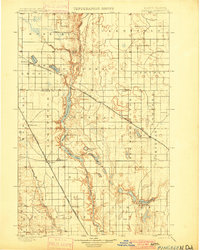 1900 Pingree1900 Print · USGSStutsman and Foster counties come alive in the final years of the nineteenth century as railroads began to stitch together the vast prairie. Researchers can trace the early rail stops at Pingree, Kensal, and Buchanan alongside the waters of Jim Lake and Spiritwood Lake.2 unique versions available
 - 1950 Map of Fried, 1978 Print
 1950 Fried1978 Print · USGSStutsman County prairie life is documented here during the mid-century, before the consolidation of rural school districts. Genealogists and local historians can locate early landmarks like Fried, Blue Lake, and the numbered sites of School No 1 and School No 2.
 - 1951 Map of Fried
 1951 Fried1951 Print · USGSStutsman County's rural landscape is captured here in the early fifties, following the course of the James River and its broad valley. Genealogists and local historians can locate the community of Fried and the specific locations of School No 1 and School No 2.
 - 1952 Map of New Rockford, 1968 Print
 1952 New Rockford1968 Print · USGSThe North Dakota prairie during the mid-1950s was a landscape of rail-dependent farm towns and vast wildlife refuges. Genealogists and historians can trace the foundations of local communities at Fort Totten Indian Agenc, Concordia Lutheran Church, and the Bowdon Country Church and Cemetery.3 unique versions available
 - 1956 Map of New Rockford
 1956 New Rockford1956 Print · USGSMid-century central North Dakota is captured here as a landscape of prairie rail towns and vast wildlife refuges. Trace family roots at the Bowdon Country Church and Cemetery or locate the old St Michael Mission School and Fort Totten.
 - 1971 Map of New Rockford, 1974 Print
 1971 New Rockford1974 Print · USGSCentral North Dakota was a landscape of wildlife refuges and rail-linked agricultural towns in the early seventies. Genealogists and local historians can trace the development of the Fort Totten Indian Reservation and locate old railway points like Maddock, Hamal, and Kloten.
 - 1985 Map of Cooperstown
 1985 Cooperstown1985 Print · USGSGriggs and Barnes Counties are seen here in the mid-eighties, a period where the prairie economy centered on rail lines and river reservoirs. Genealogists and local historians can trace family locations near Wimbledon, Hannaford, and Spiritwood Lake or locate the Fish Hatchery and Gaging Station along the Sheyenne River.2 unique versions available
 - 1990 Map of Fried, 1995 Print
 1990 Fried1995 Print · USGSStutsman County in the 1990s showcases a landscape of prairie potholes and reservoirs during a period of transition for rural agricultural hubs. Genealogists and local historians can locate the Fried Cem and the settlement of Fried, or trace the shoreline of the Jamestown Reservoir.
 - 2011 Map of Fried, 2011 Print
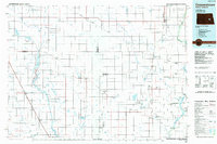
 2011 Fried2011 Print · USGSCovers Fried, including Stutsman County, United States, and other nearby areas
 - 2014 Map of Fried, 2014 Print
 2014 Fried2014 Print · USGSCovers Fried, including Stutsman County, United States, and other nearby areas
 - 2018 Map of Fried, 2018 Print
 2018 Fried2018 Print · USGSCovers Fried, including Stutsman County, United States, and other nearby areas
 - 2020 Map of Fried, 2020 Print
 2020 Fried2020 Print · USGSCovers Fried, including Stutsman County, United States, and other nearby areas
 - 2024 Map of Fried, 2024 Print
 2024 Fried2024 Print · USGSThe North Dakota prairie east of the James River comes into focus in this recent survey of rural Stutsman County. Researchers can locate the Sacred Heart Cem, trace the shoreline of Blue Lake, and explore the Jamestown Reservoir valley.
End of results
Showing maps 1-13 of 13
Top cities near Fried
- Jamestown historical maps
- Bloom historical maps
- Homer historical maps
- Wimbledon historical maps
- Eldridge historical maps
- Spiritwood Lake historical maps
See more
Frequently asked questions
- What are the different types of historical maps available for Fried?
- What is the oldest map of Fried?
- Where can I purchase historical maps of Fried for my home or office?
- Where can I download high-res historical maps of Fried?
- Are there historical topographic maps available for Fried?
- Is there historical aerial imagery available for Fried?
- Where are historical maps of Fried sourced from?