1910s Maps of Traill County, North Dakota
Explore 3 historic maps of Traill County from the 1910s. These maps offer a rare glimpse into what life looked like during the 1910s — showing old roads, neighborhoods, homes, and landmarks that have changed or disappeared over time.
Whether you're researching your family's past, planning a metal detecting trip, or studying how Traill County's landscape evolved across the 1910s, these high-resolution maps are a powerful tool for exploring the history of this region.
- Focus on a specific era: All maps on this page are from the 1910s, giving you a focused view of this time period.
- See what’s changed: Compare century-old streets, trails, and buildings to today's modern landscape using overlays and satellite layers.
- Research with precision: Use these maps for genealogy, historical research, land use analysis, or educational projects.
- View, download, or print: Maps are fully viewable online in high resolution, and can be downloaded or printed for your own records.
Start exploring Traill County's history through authentic maps from the 1910s. This is your window into the past.
Traill County, ND maps
(3)- 1918 Map of Kelso
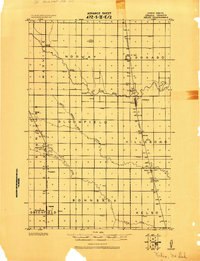 1918 Kelso1918 Print · USGSTraill County’s prairie landscape is captured here just after the Great War, showing a highly organized grid of rail towns and township schools. Genealogists can locate family roots near Blanchard, Kelso, or the Town Hall in Norway.
 - 1918 Map of Hendrum
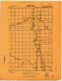 1918 Hendrum1918 Print · USGSThe Red River Valley borderlands are captured here just before the end of the Great War, showing the vital rail and river corridor between North Dakota and Minnesota. Researchers can trace the early footprints of Shelly Station, Halstad Station, and Hendrum Station along the Great Northern railroad.
 - 1919 Map of Eldred
 1919 Eldred1919 Print · USGSThe Red River Valley at the end of the Great War shows a landscape of grain elevators and riverfront settlements. Genealogists can locate family landmarks across Vineland, Sidney, and Hubbard, including Station Eldred and the Climax tall Elevator.
End of results
Showing maps 1-3 of 3
Top cities of Traill County
- Mayville historical maps
- Hillsboro historical maps
- Hatton historical maps
- Portland historical maps
- Buxton historical maps
- Galesburg historical maps
See more
Frequently asked questions
- What are the different types of historical maps available for Traill County?
- What is the oldest map of Traill County?
- Where can I purchase historical maps of Traill County for my home or office?
- Where can I download high-res historical maps of Traill County?
- Are there historical topographic maps available for Traill County?
- Is there historical aerial imagery available for Traill County?
- Where are historical maps of Traill County sourced from?