1970s Maps of Traill County, North Dakota
Explore 8 historic maps of Traill County from the 1970s. These maps offer a rare glimpse into what life looked like during the 1970s — showing old roads, neighborhoods, homes, and landmarks that have changed or disappeared over time.
Whether you're researching your family's past, planning a metal detecting trip, or studying how Traill County's landscape evolved across the 1970s, these high-resolution maps are a powerful tool for exploring the history of this region.
- Focus on a specific era: All maps on this page are from the 1970s, giving you a focused view of this time period.
- See what’s changed: Compare century-old streets, trails, and buildings to today's modern landscape using overlays and satellite layers.
- Research with precision: Use these maps for genealogy, historical research, land use analysis, or educational projects.
- View, download, or print: Maps are fully viewable online in high resolution, and can be downloaded or printed for your own records.
Start exploring Traill County's history through authentic maps from the 1970s. This is your window into the past.
Traill County, ND maps
(8)- 1970 Map of Hatton, 1972 Print
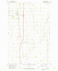
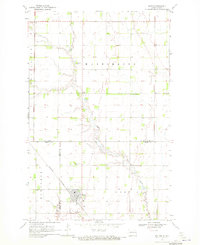 1970 Hatton1972 Print · USGSHatton and the surrounding prairie townships are captured here in the early 1970s at the intersection of Traill, Grand Forks, and Steele counties. Genealogists can locate family landmarks like St Johns Cem, Zoar Cem, and the rural Washington Prairie Ch.
 - 1970 Map of Mayville North, 1972 Print
 1970 Mayville North1972 Print · USGSTraill County agriculture and rail transit are captured here in the early seventies as the local economy centered on the river forks. Researchers can trace the Burlington Northern line through Portland Junction or locate family roots at Holmes Cem and Morgan Cem.
 - 1970 Map of Hatton SW, 1972 Print
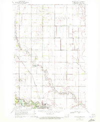
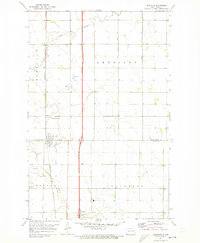
 1970 Hatton SW1972 Print · USGSPortland and the surrounding townships were captured in the early 1970s at the confluence of the Goose River branches. Genealogists and local historians can trace the paths of the Burlington Northern railroad or locate family sites near Aurdal Cem and River Park.
 - 1971 Map of Buxton SW, 1973 Print
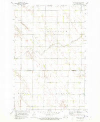
 1971 Buxton SW1973 Print · USGSTraill County in the early 1970s shows a structured prairie landscape organized into the Morgan, Buxton, Lindaas, and Wold townships. Genealogists can trace family history through sites like Asheim Cem, North Prairie Cem, and the rural Townhall.
 - 1971 Map of Buxton, 1973 Print
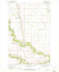
 1971 Buxton1973 Print · USGSTraill County farmland in the early seventies centers on the rail-side communities of Buxton and Cummings. Genealogists can locate several rural landmarks including Highland Ch Cem and Reeves Cem along the Buffalo Coulee.
 - 1971 Map of Buxton NW, 1973 Print
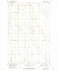
 1971 Buxton NW1973 Print · USGSThe Red River Valley prairie in the early seventies shows a landscape defined by township grids and small-scale industry. Genealogists and local historians can locate Calvary Cem, community Townhall sites, and the winding path of Cole Creek.
 - 1971 Map of Holmes, 1973 Print
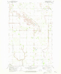
 1971 Holmes1973 Print · USGSThe Grand Forks and Traill county line in the early 1970s reveals a quiet prairie landscape organized around the village of Holmes. Genealogists and local historians can trace rural roots at Bethany Ch, Bethany Cem, and the Gensrich Landing Field.
 - 1971 Map of Reynolds, 1973 Print
 1971 Reynolds1973 Print · USGSThe Red River Valley landscape near the Traill and Grand Forks county line is captured here in the early 1970s. Researchers can trace the rail-side growth of Reynolds or locate rural landmarks like St Olaf Ch and the Americus-St Olaf Cem.
End of results
Showing maps 1-8 of 8
Top cities of Traill County
- Mayville historical maps
- Hillsboro historical maps
- Hatton historical maps
- Portland historical maps
- Buxton historical maps
- Galesburg historical maps
See more
Frequently asked questions
- What are the different types of historical maps available for Traill County?
- What is the oldest map of Traill County?
- Where can I purchase historical maps of Traill County for my home or office?
- Where can I download high-res historical maps of Traill County?
- Are there historical topographic maps available for Traill County?
- Is there historical aerial imagery available for Traill County?
- Where are historical maps of Traill County sourced from?