Old Maps of Cortland County, New York
Explore 85 old maps of Cortland County, spanning from 1897 to today. These high-resolution historic maps reveal how streets, neighborhoods, landmarks, and natural features evolved over time — perfect for genealogy, metal detecting, research, and local history exploration.
What you can do with these maps:
- See how Cortland County changed over time: Compare historical maps to modern-day views to trace roads, homesites, rail lines & more.
- View detailed metadata: Each map includes creators, publishers, year, scale, and archive source.
- Overlay maps with satellite & LiDAR: Visualize the past alongside modern tools to explore terrain & human change.
- Trusted historical sources: Maps sourced from the USGS, Library of Congress, and other archives.
- Access maps your way: View online, download high-res files, or order prints for personal or research use.
Start exploring old maps of Cortland County to uncover forgotten places, hidden landmarks, and the deep history beneath your feet.
Cortland County, NY maps
(85)- 1897 Map of Cazenovia, 1953 Print
 1897 Cazenovia1953 Print · USGSMadison and Onondaga Counties are shown here just before the turn of the century, revealing a landscape defined by emerging rail lines and historic hamlets. Researchers can trace family roots through the Cowles Settlement, locate the Constine Bridge, or follow the Lehigh Valley R. R. through Delphi Station.
 - 1898 Map of Moravia
 1898 Moravia1898 Print · USGSCentral New York at the close of the nineteenth century is captured here as a landscape of valley railroads and hilltop hamlets. You can trace the Lehigh Valley line through Moravia, find family land near Benson Corners, or locate Morse Mill and Lake Como.
 - 1899 Map of Skaneateles
 1899 Skaneateles1899 Print · USGSThe Finger Lakes at the end of the nineteenth century reveal a landscape of lakeside steamboat landings and bustling mill towns. Follow the Steamboat Route from Skaneateles to Glen Haven, or trace the rural roads connecting Marysville, Borodino, and Marcellus.
 - 1899 Map of Cazenovia
 1899 Cazenovia1899 Print · USGSMadison and Onondaga Counties are shown here in the late nineteenth century, a landscape defined by emerging lakeside villages and vital railroad junctions. Genealogists can trace early homesteads and hamlets like Cowles Settlement, Quaker Settlement, and Sheds Corners.7 unique versions available
 - 1900 Map of Tully
 1900 Tully1900 Print · USGSIn the hills south of Syracuse during the late 1890s, this area supported a network of dairy farms and rail-dependent hamlets. Genealogists can locate long-lost rural communities like Maple Grove (Case P.O.), the Onondaga Indian Reservation, and the resort grounds at Assembly Park.9 unique versions available
 - 1900 Map of Dryden
 1900 Dryden1900 Print · USGSThe Finger Lakes region comes to life in the late nineteenth century as the rail networks of the Lehigh Valley RR and the CAYUGA DIVISION expand through the valleys. Genealogists can trace family roots through the hill settlements of Caroline Center, South Danby, and the early grounds of Cornell University.9 unique versions available
 - 1902 Map of Skaneateles
 1902 Skaneateles1902 Print · USGSOnondaga and Cayuga counties come alive in the Victorian era as a network of steamboats and short-line railroads connects lakeside hamlets. Trace ancestral roots and old transport routes through Mottville, the Skaneateles RR, and remote landings like Gregory Ldg.9 unique versions available
 - 1902 Map of Moravia
 1902 Moravia1902 Print · USGSThe rural landscapes of Cayuga and Tompkins counties are captured here at the start of the twentieth century, when small hamlets thrived along the rail lines. Genealogists can trace family names and vanished post offices at Goosetree, Morse Mill, and Grotto.7 unique versions available
 - 1903 Map of Cortland
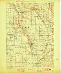
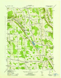
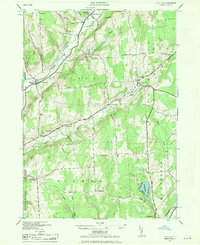
 1903 Cortland1903 Print · USGSCortland County at the turn of the century was a bustling hub of rail activity and river-valley industry. Researchers can trace the early layout of Cortland and Homer, or locate vanished operations at Crains Mills and Blodgett Mills.7 unique versions available
 - 1903 Map of Harford
 1903 Harford1903 Print · USGSThe Southern Tier of New York at the turn of the century reveals a landscape defined by deep valleys and the competing paths of the Lehigh Valley and Lackawanna railroads. Genealogists can trace early homesteads and hamlets like Harford Mills, Nanticoke, and Hunts Corners.5 unique versions available
 - 1904 Map of Greene
 1904 Greene1904 Print · USGSThe river valleys of Chenango and Broome counties come alive in this turn-of-the-century survey. You can trace the path of the Delaware Lackawanna and Western RR through Whitney Point or locate the early structures in Greene and Smithville Flats.6 unique versions available
 - 1904 Map of Pitcher
 1904 Pitcher1904 Print · USGSThe rural highlands of Central New York are documented here at the turn of the century, showing a landscape of upland hamlets and river-valley rail lines. Genealogists can trace early homesteads near Pitcher, Cincinnatus, and the remote heights of Taylor Center.5 unique versions available
 - 1906 Map of Catatonk
 1906 Catatonk1906 Print · USGSThe Southern Tier and Finger Lakes foothills are shown here at the peak of the rail era, before the expansion of modern highways. Genealogists can locate family lands near Slaterville Springs, trace the Lehigh Valley RR, or find early sites like White Church.
 - 1942 Map of Groton, 1956 Print
 1942 Groton1956 Print · USGSTompkins County rural life is captured here during the early war years, showing a landscape defined by small hamlets and a remarkable number of local schools. Trace the old Lehigh Valley rail line and locate landmarks like the George Junior Republic or Red Mills.2 unique versions available
 - 1943 Map of Spafford
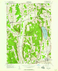
 1943 Spafford1943 Print · USGSThe steep shorelines of Skaneateles and Otisco Lakes appear here during the mid-1940s. Genealogists and local historians can trace family locations through numerous named cemeteries like Kelloggsville Cem and schools such as School No 7.
 - 1943 Map of Groton
 1943 Groton1943 Print · USGSTompkins County during the 1940s is mapped here in detail, showing a landscape of established dairy farms and rail-dependent villages. Genealogists can trace family land via numerous crossroads like Jones Corners and find old schoolhouses including the Mud Schoolhouse Corners.
 - 1943 Map of Otisco Valley
 1943 Otisco Valley1943 Print · USGSCentral New York's glacial lake country is captured here during the early 1940s, showing the rural communities of the Tully and Otisco valleys. Genealogists can locate family burial grounds like St Patricks Cem and tracing old school districts and Salt Wells.
 - 1943 Map of Sempronius, 1953 Print
 1943 Sempronius1953 Print · USGSThe rural uplands of Cayuga County come alive in this wartime survey of the Finger Lakes region. Genealogists and local historians can locate several district schools and family landmarks like Morse Mill, Lake Como, and Sand Hill Cem.2 unique versions available
 - 1943 Map of Tully, 1953 Print
 1943 Tully1953 Print · USGSThe Onondaga and Cortland County borderlands are seen here in the early 1940s, showing a landscape of upland ridges and rail-connected valley towns. Trace local ancestry through the STATE COLLEGE EXPERIMENTAL STATION, numerous rural schools, and sites like St Leos Cem and Apulia Station.
 - 1943 Map of De Ruyter, 1958 Print
 1943 De Ruyter1958 Print · USGSUpper New York State’s high country at the start of the 1940s shows a landscape of ridge-top farms and valley rail lines. Trace the Lehigh Valley Railroad corridor past De Ruyter Reservoir and find vanished district sites like School No 11 and Cowles Settlement.4 unique versions available
 - 1943 Map of Cincinnatus, 1960 Print
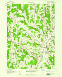 1943 Cincinnatus1960 Print · USGSCortland County during the mid-1940s remained a landscape of tight-knit valley settlements and upland district schools. Genealogists can trace family roots through sites like Hawley Cem or follow the path of the Delaware Lackawanna and Western railroad.3 unique versions available
 - 1943 Map of Cuyler, 1960 Print
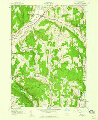 1943 Cuyler1960 Print · USGSCortland County at the height of the war years reveals a landscape of upland farms and valley hamlets. Genealogists can trace local roots through numerous district sites like Black Warrior Sch and Potter Hill Cem or the rails of the Lehigh Valley.4 unique versions available
 - 1943 Map of Pitcher, 1970 Print
 1943 Pitcher1970 Print · USGSThe Otselic River valley and the rural uplands of Chenango County are captured here during the early 1940s. Genealogists can locate several family cemeteries, including Hinman Cem, and trace the locations of old schools like School No. 3 and School No. 6.2 unique versions available
 - 1944 Map of Homer
 1944 Homer1944 Print · USGSThe Tioughnioga River valleys in the 1940s were centers of agriculture and rail transport. Genealogists can trace family footprints at Atwater Cem or locate old schoolhouses like School No 10 and the former County Farm.
 - 1944 Map of Cortland
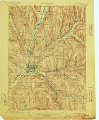
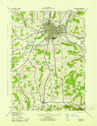 1944 Cortland1944 Print · USGSMid-century Cortland and Homer are depicted here at a peak of rail-based industry and civic growth. Genealogists and local historians can trace family roots through numerous district schools, cemeteries like Rural Cem, and the rural community around Virgil.
Showing maps 1-25 of 85
Top cities of Cortland County
- Cortland historical maps
- Cortlandville historical maps
- Homer historical maps
- Virgil historical maps
- Marathon historical maps
- Preble historical maps
See more
Frequently asked questions
- What are the different types of historical maps available for Cortland County?
- What is the oldest map of Cortland County?
- Where can I purchase historical maps of Cortland County for my home or office?
- Where can I download high-res historical maps of Cortland County?
- Are there historical topographic maps available for Cortland County?
- Is there historical aerial imagery available for Cortland County?
- Where are historical maps of Cortland County sourced from?