Old Maps of Allen County, Ohio for Metal Detecting
Plan your next treasure hunt with 90 historic maps of Allen County. Find old homesites, ghost towns, trails, and gathering spots that may be lost to time — perfect for identifying promising metal detecting locations.
- Locate forgotten sites: Uncover places like long-lost settlements, abandoned rail lines, or gathering spots.
- Plan better hunts: Use map overlays combined with LiDAR or satellite views to narrow in on historically rich areas.
- Made for detectorists: Thousands of hobbyists use these maps to discover relics, coins, and hidden history.
Use these historic maps to boost your research and find new opportunities beneath the surface of Allen County.
Allen County, OH maps
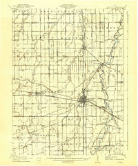
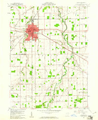
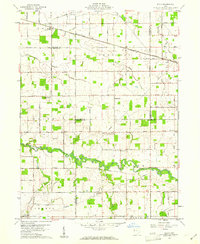
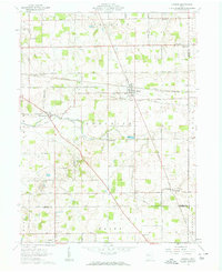
(90)- 1906 Map of Lima, 1943 Print
 1906 Lima1943 Print · USGSNorthwest Ohio’s industrial heart beats at the turn of the century, dominated by a dense rail network. Trace the early Buckeye oil era through the Oil Tanks near Lima or locate family roots in Cridersville, Uniopolis, and Wapakoneta.2 unique versions available
 - 1906 Map of Columbus Grove, 1956 Print
 1906 Columbus Grove1956 Print · USGSIn the early twentieth century, Putnam and Allen Counties were centers of Ohio's rail and pike expansion. Researchers can trace historic transportation lines like the Ohio Electric Railway and locate long-standing community landmarks such as Leatherwood Church, Kalida, and Slabtown.
 - 1907 Map of Bluffton
 1907 Bluffton1907 Print · USGSNorthwestern Ohio at the height of the steam and electric rail era shows a landscape of growing college towns and productive farmland. Trace the intersection of the Ohio Northern RR and Lake Erie and Western RR, or find vanished community hubs like Lafayette Herring PO and the Hillsville School.3 unique versions available
 - 1908 Map of Columbus Grove, 1932 Print
 1908 Columbus Grove1932 Print · USGSNorthwestern Ohio at the start of the century reveals a landscape undergoing a rapid rail-driven expansion. Researchers can trace the path of the Lima and Pittsburg Electric RR and locate rural landmarks like the Leatherwood Church or the County Infirmary.
 - 1911 Map of Spencerville, 1942 Print
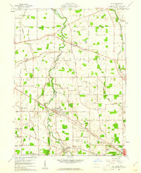
 1911 Spencerville1942 Print · USGSWestern Ohio in the early 1900s was a hub of canal and rail transport, anchored by the industrial and shipping activity in St Marys. Genealogists and historians can trace numerous rural schoolhouses like Hardscrabble School and the path of the Miami and Erie Canal.
 - 1911 Map of Delphos, 1942 Print
 1911 Delphos1942 Print · USGSNorthwest Ohio at the height of the steam and electric rail era shows a landscape deeply organized by section lines and turnpikes. Genealogists can trace rural family life through dozens of named sites like Eickholt School, Horeb Church, and the town of Landeck.
 - 1913 Map of Alger
 1913 Alger1913 Print · USGSWestern Ohio's agricultural heartland is documented here just before the Great War, showing a landscape shaped by drainage ditches and rail lines. Locate family landmarks like the Bee Hive School, Mt Zion Church, and the vanished stops along the Chicago & Erie Railroad.2 unique versions available
 - 1915 Map of Alger
 1915 Alger1915 Print · USGSNorthwest Ohio's agricultural and rail heartland is captured here just before the First World War. Genealogists can locate family homesteads near dozens of early rural schoolhouses like Kingsley School and trace the paths of the ERIE RR and LAKEVIEW ELECTRIC ROAD.4 unique versions available
 - 1943 Map of Alger
 1943 Alger1943 Print · USGSDuring the early 1940s, this pocket of Ohio was a landscape of rail-fed villages and drainage ditches. Trace family roots across a grid of rural schools like Sugarfree Sch, follow the Erie RR through Alger, or explore the shores of Indian Lake.
 - 1944 Map of Delphos
 1944 Delphos1944 Print · USGSThe rail-and-river landscape of West-Central Ohio is captured here during the mid-forties, showing the intersection of three counties. Genealogists can locate family roots via dozen of named schools like Raabe Sch and churches such as Morris Chapel or the Mennonite Cem.
 - 1944 Map of Spencerville
 1944 Spencerville1944 Print · USGSMid-century Western Ohio is shown here at the height of its rail and canal era. Genealogists can trace family roots through dozens of rural landmarks like Deep Cut Sch, Walnut Grove Church, and the Artesian Well at St Marys.
 - 1950 Map of Marion
 1950 Marion1950 Print · USGSCentral Ohio was a powerhouse of rail and river industry at the mid-century point, serving as a vital corridor between the Great Lakes and the Ohio River valley. Genealogists and rail historians can trace the paths of the Erie RR and Nickel Plate Road through towns like Bucyrus, Galion, and Upper Sandusky.
 - 1953 Map of Muncie, 1966 Print
 1953 Muncie1966 Print · USGSIndiana and Ohio borderlands thrive in the early fifties, showing a landscape defined by manufacturing cities and an intensive railroad network. Genealogists can trace family roots across the Indiana-Ohio line through Muncie, Celina, and Portland via the Pennsylvania railroad.5 unique versions available
 - 1956 Map of Muncie
 1956 Muncie1956 Print · USGSEastern Indiana and western Ohio are shown at a peak of rail-driven industry in the mid-fifties. Genealogists and rail historians can trace the paths of the Pennsylvania RR through Muncie or locate landmarks like Lake Saint Marys (Grand Lake Reservoir) and Frances Slocum State Forest.
 - 1960 Map of Columbus Grove, 1961 Print
 1960 Columbus Grove1961 Print · USGSColumbus Grove in the early sixties sits at a busy tri-rail junction where the landscape is still marked by the Old Indian Treaty Boundary. Genealogists can trace family lands along Trumbo Road and locate several burial sites like Bogart Cem and Truro Cem.2 unique versions available
 - 1960 Map of Bluffton, 1961 Print
 1960 Bluffton1961 Print · USGSAgricultural life in Allen and Putnam counties reached a mid-century peak when rail lines and country roads still defined the local economy. Genealogists and historians can trace family-named landmarks like Hilty Cem and institutional hubs such as Bluffton College.4 unique versions available
 - 1960 Map of Delphos, 1961 Print
 1960 Delphos1961 Print · USGSDelphos and the surrounding farm townships of Allen and Van Wert counties are captured here at the start of the 1960s. Researchers can trace the legacy of the Miami and Erie Canal (Abandoned) alongside active rail lines and rural landmarks like Morris Chapel and Landeck.3 unique versions available
 - 1960 Map of Cairo, 1961 Print
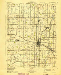
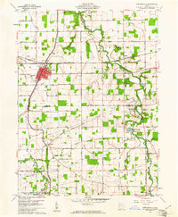
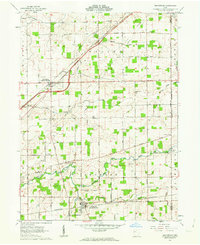
 1960 Cairo1961 Print · USGSAllen County farmland meets the industrial expansion of Lima during the early sixties, showing a landscape defined by heavy rail and institutional grounds. Genealogists can trace family sites like Altstaetter Cem, the crossroads at Cairo, and the Lima State Hospital.4 unique versions available
 - 1960 Map of Spencerville, 1961 Print
 1960 Spencerville1961 Print · USGSSpencerville and the surrounding farm country are captured here in the early sixties as the landscape transition from canal-era roots to mid-century industry. Genealogists and historians can trace the Miami and Erie Canal, Fort Amanda State Park, and local sites like St Patricks Cem.3 unique versions available
 - 1960 Map of Middle Point, 1961 Print
 1960 Middle Point1961 Print · USGSWestern Ohio farm country and rail corridors are preserved here as they appeared in the early sixties. Genealogists and local researchers can trace family lands near Venedocia and Landeck or locate burials at King Cem and Horeb Cem.3 unique versions available
 - 1960 Map of Elgin, 1961 Print
 1960 Elgin1961 Print · USGSWestern Ohio farmland is captured here in the early sixties at the meeting point of four counties. Genealogists and historians can trace family-named landmarks like Fissel Lauth Cem and Hankin Cem or locate the village of Elgin along the Erie Lackawanna Railroad.
 - 1960 Map of Elida, 1961 Print
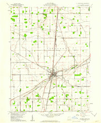
 1960 Elida1961 Print · USGSAllen County at the dawn of the 1960s shows a landscape of river-valley villages and productive farmland on the edge of a growing industrial center. Genealogists and researchers can map the specific locations of Christian Mennonite Sch, Greenlawn Cem, and Gomer.3 unique versions available
 - 1961 Map of Lima, 1962 Print
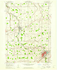
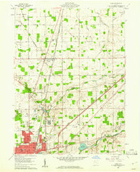
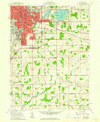 1961 Lima1962 Print · USGSAllen and Auglaize counties were reaching their mid-century peak in this early 1960s survey of the local rail and water infrastructure. Researchers can trace the path of the Old Indian Treaty Boundary or locate family sites at Fletcher Cem and Victory Ch.4 unique versions available
 - 1961 Map of Beaverdam, 1963 Print
 1961 Beaverdam1963 Print · USGSBeaverdam and Lafayette serve as local hubs in this 1960s survey of western Ohio's rail and river country. Researchers can trace rural lineages through numerous sites like Gratz Cem, Woodland Cem, and Liberty Chapel along the Ottawa River.3 unique versions available
 - 1961 Map of Harrod, 1963 Print
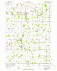
 1961 Harrod1963 Print · USGSThe rural landscape of Allen and Auglaize Counties in the early sixties centers on the ERIE LACKAWANNA rail line and the Auglaize River. Genealogists can trace family footprints across dozens of local sites, including Harrod, West Newton, and Salem Cem.2 unique versions available
Showing maps 1-25 of 90
Top cities of Allen County
- Lima historical maps
- Fort Shawnee historical maps
- Spencerville historical maps
- Elida historical maps
- Cairo historical maps
- Harrod historical maps
See more
Frequently asked questions
- What are the different types of historical maps available for Allen County?
- What is the oldest map of Allen County?
- Where can I purchase historical maps of Allen County for my home or office?
- Where can I download high-res historical maps of Allen County?
- Are there historical topographic maps available for Allen County?
- Is there historical aerial imagery available for Allen County?
- Where are historical maps of Allen County sourced from?