1980s Maps of Ashtabula County, Ohio
Explore 5 historic maps of Ashtabula County from the 1980s. These maps offer a rare glimpse into what life looked like during the 1980s — showing old roads, neighborhoods, homes, and landmarks that have changed or disappeared over time.
Whether you're researching your family's past, planning a metal detecting trip, or studying how Ashtabula County's landscape evolved across the 1980s, these high-resolution maps are a powerful tool for exploring the history of this region.
- Focus on a specific era: All maps on this page are from the 1980s, giving you a focused view of this time period.
- See what’s changed: Compare century-old streets, trails, and buildings to today's modern landscape using overlays and satellite layers.
- Research with precision: Use these maps for genealogy, historical research, land use analysis, or educational projects.
- View, download, or print: Maps are fully viewable online in high resolution, and can be downloaded or printed for your own records.
Start exploring Ashtabula County's history through authentic maps from the 1980s. This is your window into the past.
Ashtabula County, OH maps
(5)- 1985 Map of Erie, 1986 Print
 1985 Erie1986 Print · USGSThe Pennsylvania lakefront and the city of Erie are documented here in the mid-eighties, highlighting the region's transition from industrial hub to regional center. Genealogists and researchers can trace the neighborhoods of Wesleyville and Lake City or locate landmarks like Waldameer Park and the Conrail lines.
 - 1985 Map of Cleveland North, 1986 Print
 1985 Cleveland North1986 Print · USGSThe Ohio shoreline of Lake Erie in the mid-1980s reveals a bustling landscape of industrial rail lines and expanding lakefront communities. Trace the infrastructure of the era through Burke Lakefront Airport, the sprawling CONRAIL lines, and parks like Headlands Beach State Park.
 - 1986 Map of Ashtabula
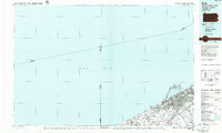
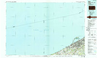
 1986 Ashtabula1986 Print · USGSThe Lake Erie shoreline and the rural borderlands of Ohio and Pennsylvania are captured here as they appeared in the 1980s. You can trace industrial rail lines like the BESSEMER AND LAKE ERIE or locate family sites near Kelloggsville Cem and Pymatuning State Park.2 unique versions available
 - 1986 Map of Youngstown, 1988 Print
 1986 Youngstown1988 Print · USGSThe industrial corridor of the Mahoning Valley and the collegiate towns of Western Pennsylvania are captured here in the mid-eighties. Researchers can trace the rail lines of the Conrail network or locate historical sites like Churchill and Crown Hill Cem.2 unique versions available
 - 1988 Map of Erie, 1989 Print
 1988 Erie1989 Print · USGSThe Lake Erie shoreline in the late eighties reveals a landscape of industrial hubs and coastal recreation. Genealogists and local historians can trace the footprints of Millcreek, the protected waters of Misery Bay, and the historic Lighthouse at the edge of the lake.
End of results
Showing maps 1-5 of 5
Top cities of Ashtabula County
- Ashtabula historical maps
- Conneaut historical maps
- Geneva historical maps
- Jefferson historical maps
- Jefferson Township historical maps
- North Kingsville historical maps
See more
Frequently asked questions
- What are the different types of historical maps available for Ashtabula County?
- What is the oldest map of Ashtabula County?
- Where can I purchase historical maps of Ashtabula County for my home or office?
- Where can I download high-res historical maps of Ashtabula County?
- Are there historical topographic maps available for Ashtabula County?
- Is there historical aerial imagery available for Ashtabula County?
- Where are historical maps of Ashtabula County sourced from?