1900-1909 Maps of Athens County, Ohio
Explore 13 historic maps of Athens County from 1900-1909. These maps offer a rare glimpse into what life looked like during the 1900s — showing old roads, neighborhoods, homes, and landmarks that have changed or disappeared over time.
Whether you're researching your family's past, planning a metal detecting trip, or studying how Athens County's landscape evolved across the 1900s, these high-resolution maps are a powerful tool for exploring the history of this region.
- Focus on a specific era: All maps on this page are from the 1900s, giving you a focused view of this time period.
- See what’s changed: Compare century-old streets, trails, and buildings to today's modern landscape using overlays and satellite layers.
- Research with precision: Use these maps for genealogy, historical research, land use analysis, or educational projects.
- View, download, or print: Maps are fully viewable online in high resolution, and can be downloaded or printed for your own records.
Start exploring Athens County's history through authentic maps from the 1900s. This is your window into the past.
Athens County, OH maps
(13)- 1902 Map of Parkersburg
 1902 Parkersburg1902 Print · USGSThe river-and-rail corridor between Ohio and West Virginia comes alive at the dawn of the twentieth century. Researchers can trace the early footprints of Parkersburg and Vienna, the sprawling Blennerhassett Island, and the old rail lines at Belpre.
 - 1903 Map of Athens, 1958 Print
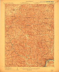
 1903 Athens1958 Print · USGSSoutheast Ohio's Hocking Valley thrives at the height of its coal-mining era, before the shift in regional industry. Researchers can trace historic rail lines like the Electric railway and find vanished company towns such as Orbiston, Buchtel, and Cawthorn.
 - 1904 Map of Parkersburg
 1904 Parkersburg1904 Print · USGSThe riverfront economies of Wood County and Washington County meet at the turn of the century where the Muskingum and Ohio rivers converge. Researchers can trace the early rail networks of the Baltimore and Ohio R.R. and locate family-named settlements like Gravelbank, Center Belpre, and Vincent.5 unique versions available
 - 1904 Map of Zaleski, 1955 Print
 1904 Zaleski1955 Print · USGSVinton and Hocking Counties are shown at the turn of the century as the rail-and-river economy flourished. Trace family roots and vanished landmarks in Zaleski, Moonville, and the brick-making center of Haydenville.2 unique versions available
 - 1904 Map of Chesterhill, 1957 Print
 1904 Chesterhill1957 Print · USGSSoutheast Ohio's rugged hill country is captured here during the peak of its rail-and-river economy in the early twentieth century. Researchers can locate vanished rural post offices and community landmarks like Calvary P O, Bethany Church, and Patten Mills.
 - 1905 Map of Athens
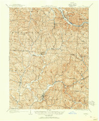
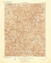
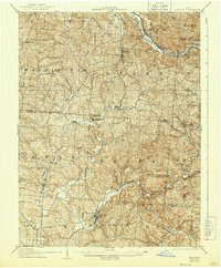
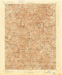
 1905 Athens1905 Print · USGSAthens and the Hocking River valley appear here at the height of the coal and rail era in the early nineteen-hundreds. Genealogists can trace family roots in vanished settlements and industrial junctions like Orbiston, Buchtel, and Marshfield.6 unique versions available
 - 1905 Map of Wilkesville, 1958 Print
 1905 Wilkesville1958 Print · USGSVinton County and its neighbors at the height of the early industrial era show a landscape shaped by charcoal furnaces and narrow-gauge rail interests. Genealogists can trace family footprints across dozens of local school districts like Auburn School or within established centers like Wilkesville and Minerton.
 - 1906 Map of Belleville
 1906 Belleville1906 Print · USGSWood County at the turn of the century is defined by its deep river valleys and the expansion of the Baltimore and Ohio RR. Genealogists and historians can trace late-Victorian settlements like Mineral Wells, Belleville, and the riverfront at Walkers Crossing.2 unique versions available
 - 1906 Map of Chesterhill, 1943 Print
 1906 Chesterhill1943 Print · USGSSoutheastern Ohio at the start of the century reveals a landscape of coal-mining hamlets and river valley rail lines. Genealogists and researchers can trace family landmarks like Mills School, Patten Mills, and the scattered post offices of Calvary PO and Federal.
 - 1907 Map of Pomeroy
 1907 Pomeroy1907 Print · USGSMeigs County at the peak of the river-and-rail era shows a landscape of busy Ohio River towns and remote hillside post offices. Genealogists can trace family footprints near Pomeroy, the Bunker Hill Church, and the dual settlement of Pagetown Downingston PO.3 unique versions available
 - 1907 Map of Keno, 1919 Print
 1907 Keno1919 Print · USGSMeigs County and the Ohio River valley appear in high detail just after the turn of the century, showing a landscape defined by river trade and rail. Researchers can trace family sites at Nease Settlement, find the Minersville PO, or locate old schools like Morningstar School and Redbrush School.3 unique versions available
 - 1907 Map of Zaleski, 1944 Print
 1907 Zaleski1944 Print · USGSVinton and Hocking counties at the turn of the century show an era of intense industrial activity along the coal branches. Trace the paths of the Baltimore and Ohio Southwestern RR through Moonville or find old homesteads near New Plymouth and Zaleski.
 - 1908 Map of Wilkesville, 1943 Print
 1908 Wilkesville1943 Print · USGSThe Vinton County hills are seen here during a peak era of iron furnaces and rail expansion before the Great War. Genealogists and researchers can trace dozens of family-named landmarks and institutions, from the Vinton Furnace site to Boring Church and the Haggerty School.
End of results
Showing maps 1-13 of 13
Top cities of Athens County
Frequently asked questions
- What are the different types of historical maps available for Athens County?
- What is the oldest map of Athens County?
- Where can I purchase historical maps of Athens County for my home or office?
- Where can I download high-res historical maps of Athens County?
- Are there historical topographic maps available for Athens County?
- Is there historical aerial imagery available for Athens County?
- Where are historical maps of Athens County sourced from?