1990s Maps of Lodi Township, Ohio
Explore 3 historic maps of Lodi Township from the 1990s. These maps offer a rare glimpse into what life looked like during the 1990s — showing old roads, neighborhoods, homes, and landmarks that have changed or disappeared over time.
Whether you're researching your family's past, planning a metal detecting trip, or studying how Lodi Township's landscape evolved across the 1990s, these high-resolution maps are a powerful tool for exploring the history of this region.
- Focus on a specific era: All maps on this page are from the 1990s, giving you a focused view of this time period.
- See what’s changed: Compare century-old streets, trails, and buildings to today's modern landscape using overlays and satellite layers.
- Research with precision: Use these maps for genealogy, historical research, land use analysis, or educational projects.
- View, download, or print: Maps are fully viewable online in high resolution, and can be downloaded or printed for your own records.
Start exploring Lodi Township's history through authentic maps from the 1990s. This is your window into the past.
Lodi Township, OH maps
(3)- 1992 Map of Shade, 1995 Print
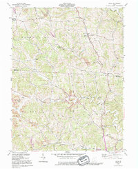 1992 Shade1995 Print · USGSThe rural hills of southeastern Ohio are captured here in the early nineties, showing a landscape defined by ridgeline roads and deep creek valleys. Genealogists and historians can trace family names at Jerseyville Cem, find old rural outposts like Burlingham Sch, and follow the winding Pratts Fork.
 - 1994 Map of Alfred, 1998 Print
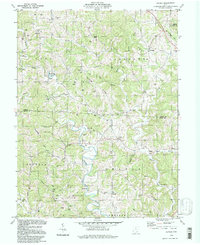 1994 Alfred1998 Print · USGSIn the hills of Athens and Meigs counties during the 1990s, the landscape remained a busy corridor for energy extraction. Researchers can trace dozens of family cemeteries and old rural hubs like Anthony, Sumner, and the Covered Bridge near Garden.
 - 1994 Map of Stewart, 1998 Print
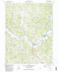 1994 Stewart1998 Print · USGSAthens County hill country comes into focus in the mid-nineties, where river-valley life meets the deep woods of the Wayne National Forest. Genealogists can trace family footprints at Copeland Cem or follow the Hocking River to the village of Stewart.
End of results
Showing maps 1-3 of 3
Top cities near Lodi Township
- Athens historical maps
- Nelsonville historical maps
- The Plains historical maps
- Chester historical maps
- Pomeroy historical maps
- Chauncey historical maps
See more
Top neighborhoods of Lodi Township
- Pratts Fork historical maps
- Anthony historical maps
- Garden historical maps
- Carsey Town historical maps
- Shade historical maps
- Hull historical maps
Frequently asked questions
- What are the different types of historical maps available for Lodi Township?
- What is the oldest map of Lodi Township?
- Where can I purchase historical maps of Lodi Township for my home or office?
- Where can I download high-res historical maps of Lodi Township?
- Are there historical topographic maps available for Lodi Township?
- Is there historical aerial imagery available for Lodi Township?
- Where are historical maps of Lodi Township sourced from?