1960s Maps of Lodi Township, Ohio
Explore 8 historic maps of Lodi Township from the 1960s. These maps offer a rare glimpse into what life looked like during the 1960s — showing old roads, neighborhoods, homes, and landmarks that have changed or disappeared over time.
Whether you're researching your family's past, planning a metal detecting trip, or studying how Lodi Township's landscape evolved across the 1960s, these high-resolution maps are a powerful tool for exploring the history of this region.
- Focus on a specific era: All maps on this page are from the 1960s, giving you a focused view of this time period.
- See what’s changed: Compare century-old streets, trails, and buildings to today's modern landscape using overlays and satellite layers.
- Research with precision: Use these maps for genealogy, historical research, land use analysis, or educational projects.
- View, download, or print: Maps are fully viewable online in high resolution, and can be downloaded or printed for your own records.
Start exploring Lodi Township's history through authentic maps from the 1960s. This is your window into the past.
Lodi Township, OH maps
(8)- 1960 Map of Alfred, 1961 Print
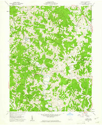 1960 Alfred1961 Print · USGSSoutheast Ohio's ridge country at the start of the sixties reveals a landscape of winding river branches and emerging oil and gas fields. Genealogists can trace family roots through numerous sites like Bishop Cem, the community at Lottridge, and the rural Zion Ch.3 unique versions available
 - 1960 Map of Shade, 1962 Print
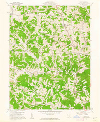 1960 Shade1962 Print · USGSMeigs and Athens Counties at the start of the sixties were defined by the extractive industries and rural crossroads of the Appalachian Plateau. Genealogists and historians can trace family locations through numerous sites like Jeffers Cem, the Burlingham Ch, and the old Bedford Sch.3 unique versions available
 - 1961 Map of Columbus
 1961 Columbus1961 Print · USGSCentral and Southern Ohio are captured here in the early sixties, as the region's industrial rail hubs and military bases reached their peak. Genealogists and historians can trace the transition from urban Columbus to rural townships along the Scioto River, locating Lockbourne USAF and old junctions like Washington Court House.
 - 1961 Map of Clarksburg
 1961 Clarksburg1961 Print · USGSThe mid-century industrial and river landscapes of West Virginia and Ohio are detailed here, centered on the Ohio River. Researchers can trace the Baltimore and Ohio rail lines connecting towns like Parkersburg, Clarksburg, and Monongah.
 - 1961 Map of Athens, 1962 Print
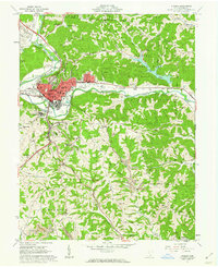 1961 Athens1962 Print · USGSAthens is shown in the early sixties at a moment of transition, balancing its role as a university center with an active industrial landscape. Genealogists can trace family names at McCole Cem or Graham Chapel Cem, while industrial historians can locate old Strip Mines and the N Y C rail lines.7 unique versions available
 - 1961 Map of Stewart, 1962 Print
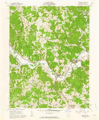 1961 Stewart1962 Print · USGSAthens County at the start of the sixties reveals a landscape of winding river valleys and ridge-top oil fields. Trace the old Baltimore and Ohio rail line through Guysville and Stewart, or find rural landmarks like Asbury Ch and Kilvert.4 unique versions available
 - 1962 Map of Columbus
 1962 Columbus1962 Print · USGSCentral Ohio during the early sixties reveals a transition from the industrial corridors of Columbus to the forested ridges of the south. Genealogists and historians can trace the rail networks of the Baltimore & Ohio RR and find local landmarks like Washington Court House and Camp Sherman Military Reservation.
 - 1967 Map of Columbus, 1969 Print
 1967 Columbus1969 Print · USGSCentral Ohio during the late sixties serves as a vital corridor of rail and aviation, from the industrial streets of Springfield to the hangar lines of Lockbourne Air Force Base. Genealogists and researchers can trace the growth of towns like Circleville and London or locate rural landmarks such as St Paul church and the London Correctional Institution.2 unique versions available
End of results
Showing maps 1-8 of 8
Top cities near Lodi Township
- Athens historical maps
- Nelsonville historical maps
- The Plains historical maps
- Chester historical maps
- Pomeroy historical maps
- Chauncey historical maps
See more
Top neighborhoods of Lodi Township
- Pratts Fork historical maps
- Anthony historical maps
- Garden historical maps
- Carsey Town historical maps
- Shade historical maps
- Hull historical maps
Frequently asked questions
- What are the different types of historical maps available for Lodi Township?
- What is the oldest map of Lodi Township?
- Where can I purchase historical maps of Lodi Township for my home or office?
- Where can I download high-res historical maps of Lodi Township?
- Are there historical topographic maps available for Lodi Township?
- Is there historical aerial imagery available for Lodi Township?
- Where are historical maps of Lodi Township sourced from?