1940s Maps of Auglaize County, Ohio
Explore 5 historic maps of Auglaize County from the 1940s. These maps offer a rare glimpse into what life looked like during the 1940s — showing old roads, neighborhoods, homes, and landmarks that have changed or disappeared over time.
Whether you're researching your family's past, planning a metal detecting trip, or studying how Auglaize County's landscape evolved across the 1940s, these high-resolution maps are a powerful tool for exploring the history of this region.
- Focus on a specific era: All maps on this page are from the 1940s, giving you a focused view of this time period.
- See what’s changed: Compare century-old streets, trails, and buildings to today's modern landscape using overlays and satellite layers.
- Research with precision: Use these maps for genealogy, historical research, land use analysis, or educational projects.
- View, download, or print: Maps are fully viewable online in high resolution, and can be downloaded or printed for your own records.
Start exploring Auglaize County's history through authentic maps from the 1940s. This is your window into the past.
Auglaize County, OH maps
(5)- 1943 Map of Alger
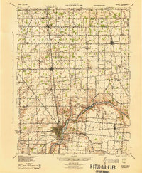
 1943 Alger1943 Print · USGSDuring the early 1940s, this pocket of Ohio was a landscape of rail-fed villages and drainage ditches. Trace family roots across a grid of rural schools like Sugarfree Sch, follow the Erie RR through Alger, or explore the shores of Indian Lake.
 - 1944 Map of Sidney
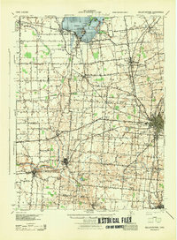
 1944 Sidney1944 Print · USGSShelby County thrived as a rail and river hub in the mid-1940s, centered on the growing industrial town of Sidney. Researchers can trace old rural school districts and family-named landmarks such as Walnut Grove Sch, Poplar Knob, and the Childrens Home.
 - 1944 Map of Loramie
 1944 Loramie1944 Print · USGSWest-central Ohio farmland is captured here during the mid-forties, showing the intricate grid of rural school districts and turnpikes. Researchers can trace family-named sites like Fledderjohn Sch and St Patricks Ch near the Loramie Reservoir.
 - 1944 Map of Spencerville
 1944 Spencerville1944 Print · USGSMid-century Western Ohio is shown here at the height of its rail and canal era. Genealogists can trace family roots through dozens of rural landmarks like Deep Cut Sch, Walnut Grove Church, and the Artesian Well at St Marys.
 - 1944 Map of Bellefontaine
 1944 Bellefontaine1944 Print · USGSLogan County in the 1940s centers on the bustling rail junction of Bellefontaine and the recreational shores of Indian Lake. Genealogists and local historians can locate early landmarks like the County Infirmary and dozens of rural schoolhouses, including McKee Creek Sch and Miller Sch.
End of results
Showing maps 1-5 of 5
Top cities of Auglaize County
- Wapakoneta historical maps
- Saint Marys historical maps
- New Bremen historical maps
- Minster historical maps
- Cridersville historical maps
- Moulton historical maps
See more
Frequently asked questions
- What are the different types of historical maps available for Auglaize County?
- What is the oldest map of Auglaize County?
- Where can I purchase historical maps of Auglaize County for my home or office?
- Where can I download high-res historical maps of Auglaize County?
- Are there historical topographic maps available for Auglaize County?
- Is there historical aerial imagery available for Auglaize County?
- Where are historical maps of Auglaize County sourced from?