1960s Maps of New Bremen, Ohio
Explore 2 historic maps of New Bremen from the 1960s. These maps offer a rare glimpse into what life looked like during the 1960s — showing old roads, neighborhoods, homes, and landmarks that have changed or disappeared over time.
Whether you're researching your family's past, planning a metal detecting trip, or studying how New Bremen's landscape evolved across the 1960s, these high-resolution maps are a powerful tool for exploring the history of this region.
- Focus on a specific era: All maps on this page are from the 1960s, giving you a focused view of this time period.
- See what’s changed: Compare century-old streets, trails, and buildings to today's modern landscape using overlays and satellite layers.
- Research with precision: Use these maps for genealogy, historical research, land use analysis, or educational projects.
- View, download, or print: Maps are fully viewable online in high resolution, and can be downloaded or printed for your own records.
Start exploring New Bremen's history through authentic maps from the 1960s. This is your window into the past.
New Bremen, OH maps
(2)- 1961 Map of New Knoxville, 1962 Print
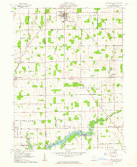 1961 New Knoxville1962 Print · USGSWestern Ohio farmland and the waters of Lake Loramie are frozen in time during the early sixties. Genealogists can locate family-named cemeteries like Pilger Ruhe Cem while historians trace legacy infrastructure at Lock Two and Lehmkuhl Landing.3 unique versions available
 - 1961 Map of New Bremen, 1963 Print
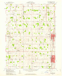 1961 New Bremen1963 Print · USGSAgricultural West-Central Ohio comes alive in the early sixties, showing the vital canal and rail corridors through the Auglaize and Mercer county border. Trace family roots through the Maria Stein Shrine or settlements like Egypt and Chickasaw.
End of results
Showing maps 1-2 of 2
Top cities near New Bremen
- Sidney historical maps
- Celina historical maps
- Wapakoneta historical maps
- Saint Marys historical maps
- Minster historical maps
- Versailles historical maps
See more
Frequently asked questions
- What are the different types of historical maps available for New Bremen?
- What is the oldest map of New Bremen?
- Where can I purchase historical maps of New Bremen for my home or office?
- Where can I download high-res historical maps of New Bremen?
- Are there historical topographic maps available for New Bremen?
- Is there historical aerial imagery available for New Bremen?
- Where are historical maps of New Bremen sourced from?