1990s Maps of Bellaire, Ohio
Explore 3 historic maps of Bellaire from the 1990s. These maps offer a rare glimpse into what life looked like during the 1990s — showing old roads, neighborhoods, homes, and landmarks that have changed or disappeared over time.
Whether you're researching your family's past, planning a metal detecting trip, or studying how Bellaire's landscape evolved across the 1990s, these high-resolution maps are a powerful tool for exploring the history of this region.
- Focus on a specific era: All maps on this page are from the 1990s, giving you a focused view of this time period.
- See what’s changed: Compare century-old streets, trails, and buildings to today's modern landscape using overlays and satellite layers.
- Research with precision: Use these maps for genealogy, historical research, land use analysis, or educational projects.
- View, download, or print: Maps are fully viewable online in high resolution, and can be downloaded or printed for your own records.
Start exploring Bellaire's history through authentic maps from the 1990s. This is your window into the past.
Bellaire, OH maps
(3)- 1994 Map of Wheeling, 1998 Print
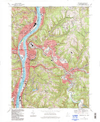 1994 Wheeling1998 Print · USGSThe Ohio River valley at the end of the twentieth century remains a dense corridor of industry and community spanning the state line. Researchers can trace historic neighborhoods from Warwood to Mozart or locate family sites at Greenwood Cemetery and Mt de Chantal Academy.
 - 1994 Map of Lansing, 1998 Print
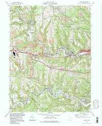 1994 Lansing1998 Print · USGSBelmont County as it appeared in the late twentieth century shows an area shaped by coal and commerce. Trace the legacy of industrial hamlets and family cemeteries from Stewartsville to Barton, or locate landmarks like Lancaster Chapel and the National Road.
 - 1997 Map of Moundsville, 1999 Print
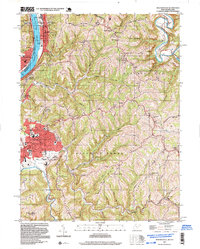 1997 Moundsville1999 Print · USGSThe Ohio River valley and its steep ridges are captured here during a period of late-twentieth-century industrial and correctional activity. Researchers can trace the massive State Penitentiary grounds, family cemeteries like Buchanan Cem, and rural centers such as Sherrard.
End of results
Showing maps 1-3 of 3
Top cities near Bellaire
- Wheeling historical maps
- Moundsville historical maps
- Martins Ferry historical maps
- St. Clairsville historical maps
- Saint Clairsville historical maps
- Colerain historical maps
See more
Frequently asked questions
- What are the different types of historical maps available for Bellaire?
- What is the oldest map of Bellaire?
- Where can I purchase historical maps of Bellaire for my home or office?
- Where can I download high-res historical maps of Bellaire?
- Are there historical topographic maps available for Bellaire?
- Is there historical aerial imagery available for Bellaire?
- Where are historical maps of Bellaire sourced from?