1900-1909 Maps of Bellaire, Ohio
Explore 3 historic maps of Bellaire from 1900-1909. These maps offer a rare glimpse into what life looked like during the 1900s — showing old roads, neighborhoods, homes, and landmarks that have changed or disappeared over time.
Whether you're researching your family's past, planning a metal detecting trip, or studying how Bellaire's landscape evolved across the 1900s, these high-resolution maps are a powerful tool for exploring the history of this region.
- Focus on a specific era: All maps on this page are from the 1900s, giving you a focused view of this time period.
- See what’s changed: Compare century-old streets, trails, and buildings to today's modern landscape using overlays and satellite layers.
- Research with precision: Use these maps for genealogy, historical research, land use analysis, or educational projects.
- View, download, or print: Maps are fully viewable online in high resolution, and can be downloaded or printed for your own records.
Start exploring Bellaire's history through authentic maps from the 1900s. This is your window into the past.
Bellaire, OH maps
(3)- 1902 Map of Wheeling
 1902 Wheeling1902 Print · USGSThe Ohio River valley at the start of the 1900s was a powerhouse of rail and river industry across West Virginia, Ohio, and Pennsylvania. Genealogists can trace family roots in early industrial hubs like Martins Ferry, locate historic landmarks like the S Bridge, or find riverfront settlements such as Beach Bottom and Yorkville.7 unique versions available
 - 1904 Map of Cameron
 1904 Cameron1904 Print · USGSMarshall County's river-and-rail economy is frozen in time at the dawn of the century, showing the dense settlement patterns of the West Virginia panhandle. Researchers can trace the Baltimore and Ohio R R through Rosbys Rock or locate rural landmarks like Beelers Station and the Waynesburg Turnpike.4 unique versions available
 - 1905 Map of St. Clairsville, 1942 Print
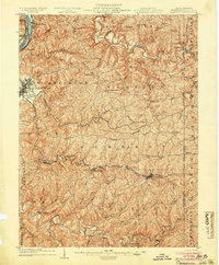
 1905 St. Clairsville1942 Print · USGSBelmont County at the start of the twentieth century was a landscape of steep ridges and vital transportation corridors. Researchers can trace the path of the National Road and locate early settlements and rail junctions like Fairpoint, Colerain, and Harrisville.2 unique versions available
End of results
Showing maps 1-3 of 3
Top cities near Bellaire
- Wheeling historical maps
- Moundsville historical maps
- Martins Ferry historical maps
- St. Clairsville historical maps
- Saint Clairsville historical maps
- Colerain historical maps
See more
Frequently asked questions
- What are the different types of historical maps available for Bellaire?
- What is the oldest map of Bellaire?
- Where can I purchase historical maps of Bellaire for my home or office?
- Where can I download high-res historical maps of Bellaire?
- Are there historical topographic maps available for Bellaire?
- Is there historical aerial imagery available for Bellaire?
- Where are historical maps of Bellaire sourced from?