1900s (20th Century) Maps of Holloway, Ohio
Explore 10 historic maps of Holloway from the 1900s (20th Century). These maps offer a rare glimpse into what life looked like during the 1900s — showing old roads, neighborhoods, homes, and landmarks that have changed or disappeared over time.
Whether you're researching your family's past, planning a metal detecting trip, or studying how Holloway's landscape evolved across the 1900s, these high-resolution maps are a powerful tool for exploring the history of this region.
- Focus on a specific era: All maps on this page are from the 1900s, giving you a focused view of this time period.
- See what’s changed: Compare century-old streets, trails, and buildings to today's modern landscape using overlays and satellite layers.
- Research with precision: Use these maps for genealogy, historical research, land use analysis, or educational projects.
- View, download, or print: Maps are fully viewable online in high resolution, and can be downloaded or printed for your own records.
Start exploring Holloway's history through authentic maps from the 1900s. This is your window into the past.
Holloway, OH maps
(10)- 1903 Map of Flushing, 1959 Print
 1903 Flushing1959 Print · USGSEastern Ohio at the turn of the century is defined here by the meeting of major rail lines and the historic National Road. Trace the path of the Cleveland Lorain and Wheeling railroad through Holloway or locate homes in Flushing.
 - 1905 Map of Flushing, 1946 Print
 1905 Flushing1946 Print · USGSEastern Ohio at the turn of the century shows a landscape defined by the National Turnpike and early rail lines. Genealogists can trace family footprints in Holloway, Sewellsville, and Morristown or along the winding Cleveland Lorain and Wheeling railroad.
 - 1951 Map of Canton
 1951 Canton1951 Print · USGSThe industrial heartland of Ohio and Pennsylvania reached its mid-century peak during this era of heavy rail and river transit. Genealogists and historians can trace the development of steel towns like Aliquippa and Weirton alongside the Ohio River and major lines of the Pennsylvania RR.
 - 1953 Map of Canton
 1953 Canton1953 Print · USGSThe industrial heartland of Ohio and Pennsylvania is captured at its mid-century peak in this detailed regional survey. Genealogists and historians can trace the vast rail networks of the Pennsylvania RR and find local landmarks like Nimisila Reservoir and Tappan Reservoir.
 - 1957 Map of Canton, 1971 Print
 1957 Canton1971 Print · USGSThe industrial heartland of eastern Ohio and western Pennsylvania comes alive in this mid-century survey of the Ohio River Valley. Trace the heritage of rail and river commerce through Pittsburgh, the massive steel towns along the Ohio River, and major junctions on the Pennsylvania RR.3 unique versions available
 - 1961 Map of Piedmont, 1962 Print
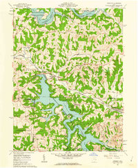 1961 Piedmont1962 Print · USGSHarrison and Belmont counties in the early sixties show a landscape transformed by the Muskingum Watershed Conservancy District. Genealogists and historians can locate the Quaker Cem, trace the Baltimore and Ohio rail lines, and find early coal Strip Mines.4 unique versions available
 - 1961 Map of Flushing, 1962 Print
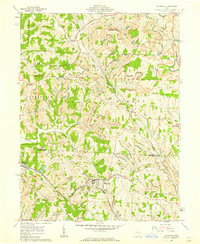 1961 Flushing1962 Print · USGSEastern Ohio hill country at the start of the sixties shows a region of deep-cut valleys and active industry. Researchers can trace the path of the Baltimore and Ohio RR and locate local landmarks like Nottingham Ch and the many Strip Mines that dot the landscape.3 unique versions available
 - 1962 Map of Canton
 1962 Canton1962 Print · USGSThe industrial heartland of Eastern Ohio and Western Pennsylvania thrives in the early sixties as steel mills and rail lines dominate the river valleys. Genealogists and historians can trace local landmarks like McKinley National Memorial, Malone College, and industrial sites such as Republic Steel Corp.2 unique versions available
 - 1994 Map of Piedmont, 1998 Print
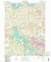 1994 Piedmont1998 Print · USGSEastern Ohio’s lake-filled landscapes and mining history are recorded here in the 1990s as reclamation efforts transformed the terrain. Genealogists can trace family sites at Belmont Ridge Cem or Quaker Cem and explore settlements like Piedmont and Holloway.
 - 1994 Map of Flushing, 1998 Print
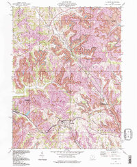 1994 Flushing1998 Print · USGSEastern Ohio's coal country in the 1990s shows a terrain defined by industrial extraction and small rural settlements. Researchers can trace the extensive Strip Mines surrounding Flushing or locate historic local landmarks like Rankin Ch and Nottingham Ch.
End of results
Showing maps 1-10 of 10
Top cities near Holloway
- Uhrichsville historical maps
- St. Clairsville historical maps
- Barnesville historical maps
- Cadiz historical maps
- Dennison historical maps
- Bethesda historical maps
See more
Frequently asked questions
- What are the different types of historical maps available for Holloway?
- What is the oldest map of Holloway?
- Where can I purchase historical maps of Holloway for my home or office?
- Where can I download high-res historical maps of Holloway?
- Are there historical topographic maps available for Holloway?
- Is there historical aerial imagery available for Holloway?
- Where are historical maps of Holloway sourced from?