1950s Maps of Morgan Township, Ohio
Explore 6 historic maps of Morgan Township from the 1950s. These maps offer a rare glimpse into what life looked like during the 1950s — showing old roads, neighborhoods, homes, and landmarks that have changed or disappeared over time.
Whether you're researching your family's past, planning a metal detecting trip, or studying how Morgan Township's landscape evolved across the 1950s, these high-resolution maps are a powerful tool for exploring the history of this region.
- Focus on a specific era: All maps on this page are from the 1950s, giving you a focused view of this time period.
- See what’s changed: Compare century-old streets, trails, and buildings to today's modern landscape using overlays and satellite layers.
- Research with precision: Use these maps for genealogy, historical research, land use analysis, or educational projects.
- View, download, or print: Maps are fully viewable online in high resolution, and can be downloaded or printed for your own records.
Start exploring Morgan Township's history through authentic maps from the 1950s. This is your window into the past.
Morgan Township, OH maps
(6)- 1953 Map of Cincinnati, 1965 Print
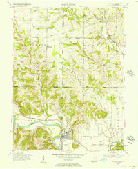
 1953 Cincinnati1965 Print · USGSThe Ohio River valley and the industrial heartland of Indiana and Ohio are captured here during the mid-century peak of rail and river commerce. Genealogists and historians can trace connections between Cincinnati and outlying military sites like Camp Atterbury and Bakalar AFB.3 unique versions available
 - 1955 Map of Harrison, 1956 Print
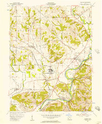
 1955 Harrison1956 Print · USGSThe borderlands of Ohio and Indiana are captured here in the mid-fifties as the villages of Harrison and West Harrison thrive along the river. Researchers can trace family roots through numerous sites like Glen Haven Cem and the Township School.5 unique versions available
 - 1955 Map of Reily, 1956 Print
 1955 Reily1956 Print · USGSThe Indiana-Ohio borderlands come into focus in the mid-1950s, showing a landscape defined by the First Principal Meridian. Genealogists and historians can trace small settlements like Mixersville and Scipio, and locate old burial sites including Springdale Cemetery and Asbury Cemetery.3 unique versions available
 - 1955 Map of Millville, 1956 Print
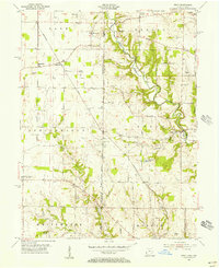
 1955 Millville1956 Print · USGSButler County in the mid-fifties remains a landscape of rail-side hamlets and rural schoolhouses. Genealogists can trace family names through sites like Minton Cem and Bethel Cem or follow the old Baltimore and Ohio line through McGonigle.4 unique versions available
 - 1955 Map of Shandon, 1957 Print
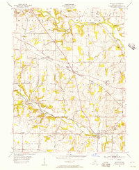
 1955 Shandon1957 Print · USGSButler and Hamilton counties in the mid-1950s reveal a mix of quiet rural townships and emerging industrial sites. Genealogists can trace family footprints through several local cemeteries like Scott Cem and Butterfield Cem or the vanished stops of Shandon Sta.
 - 1957 Map of Cincinnati
 1957 Cincinnati1957 Print · USGSThe Ohio River valley and its surrounding highlands thrived during the mid-fifties industrial peak, centered on the bustling Cincinnati and Dayton metropolitan hubs. Researchers can trace the extensive rail networks and military sites like Wright-Patterson AFB and Camp Atterbury.
End of results
Showing maps 1-6 of 6
Top cities near Morgan Township
- Cincinnati historical maps
- Hamilton historical maps
- Fairfield historical maps
- Oxford historical maps
- Forest Park historical maps
- Harrison historical maps
See more
Top neighborhoods of Morgan Township
Frequently asked questions
- What are the different types of historical maps available for Morgan Township?
- What is the oldest map of Morgan Township?
- Where can I purchase historical maps of Morgan Township for my home or office?
- Where can I download high-res historical maps of Morgan Township?
- Are there historical topographic maps available for Morgan Township?
- Is there historical aerial imagery available for Morgan Township?
- Where are historical maps of Morgan Township sourced from?