1960s Maps of Fox Township, Ohio
Explore 5 historic maps of Fox Township from the 1960s. These maps offer a rare glimpse into what life looked like during the 1960s — showing old roads, neighborhoods, homes, and landmarks that have changed or disappeared over time.
Whether you're researching your family's past, planning a metal detecting trip, or studying how Fox Township's landscape evolved across the 1960s, these high-resolution maps are a powerful tool for exploring the history of this region.
- Focus on a specific era: All maps on this page are from the 1960s, giving you a focused view of this time period.
- See what’s changed: Compare century-old streets, trails, and buildings to today's modern landscape using overlays and satellite layers.
- Research with precision: Use these maps for genealogy, historical research, land use analysis, or educational projects.
- View, download, or print: Maps are fully viewable online in high resolution, and can be downloaded or printed for your own records.
Start exploring Fox Township's history through authentic maps from the 1960s. This is your window into the past.
Fox Township, OH maps
(5)- 1960 Map of Bergholz, 1961 Print
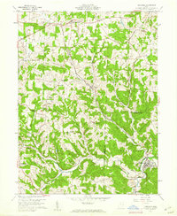 1960 Bergholz1961 Print · USGSEastern Ohio coal and rail country comes to life in the early sixties as industrial mining expands around the village of Bergholz. Genealogists and researchers can trace family roots at Spyder Cem, Palmer Cem, or the Chestnut Ridge Ch.4 unique versions available
 - 1960 Map of Kensington, 1962 Print
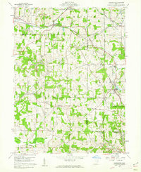 1960 Kensington1962 Print · USGSCarroll and Columbiana counties meet here in the early sixties, where coal mining and historical survey lines define the rural landscape. Genealogists and local historians can trace family locations near Summitville, Bethesda Ch, and the significant Geographers Line.3 unique versions available
 - 1960 Map of Gavers, 1962 Print
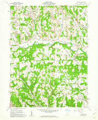 1960 Gavers1962 Print · USGSColumbiana County at the start of the sixties shows a landscape of deep-rooted settlements and active industry. Trace the legacy of early transit and mining through the Sandy-Beaver Canal Tunnel and numerous local landmarks like New Lebanon Ch and the Covered Bridge.3 unique versions available
 - 1960 Map of Salineville, 1962 Print
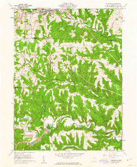 1960 Salineville1962 Print · USGSSalineville and the surrounding townships of Columbiana and Jefferson Counties are shown here during the early 1960s coal boom. Genealogists and historians can trace the rural landscape via West Grove Cem, Grants Hill Ch, and the numerous Strip Mine sites.2 unique versions available
 - 1962 Map of Canton
 1962 Canton1962 Print · USGSThe industrial heartland of Eastern Ohio and Western Pennsylvania thrives in the early sixties as steel mills and rail lines dominate the river valleys. Genealogists and historians can trace local landmarks like McKinley National Memorial, Malone College, and industrial sites such as Republic Steel Corp.2 unique versions available
End of results
Showing maps 1-5 of 5
Top cities near Fox Township
- Steubenville historical maps
- Wintersville historical maps
- Minerva historical maps
- Carrollton historical maps
- Lisbon historical maps
- Augusta historical maps
See more
Top neighborhoods of Fox Township
- Wattsville historical maps
- Scroggsfield historical maps
- Pine Hill historical maps
- Mechanicstown historical maps
Frequently asked questions
- What are the different types of historical maps available for Fox Township?
- What is the oldest map of Fox Township?
- Where can I purchase historical maps of Fox Township for my home or office?
- Where can I download high-res historical maps of Fox Township?
- Are there historical topographic maps available for Fox Township?
- Is there historical aerial imagery available for Fox Township?
- Where are historical maps of Fox Township sourced from?