1950s Maps of Columbiana County, Ohio
Explore 9 historic maps of Columbiana County from the 1950s. These maps offer a rare glimpse into what life looked like during the 1950s — showing old roads, neighborhoods, homes, and landmarks that have changed or disappeared over time.
Whether you're researching your family's past, planning a metal detecting trip, or studying how Columbiana County's landscape evolved across the 1950s, these high-resolution maps are a powerful tool for exploring the history of this region.
- Focus on a specific era: All maps on this page are from the 1950s, giving you a focused view of this time period.
- See what’s changed: Compare century-old streets, trails, and buildings to today's modern landscape using overlays and satellite layers.
- Research with precision: Use these maps for genealogy, historical research, land use analysis, or educational projects.
- View, download, or print: Maps are fully viewable online in high resolution, and can be downloaded or printed for your own records.
Start exploring Columbiana County's history through authentic maps from the 1950s. This is your window into the past.
Columbiana County, OH maps
(9)- 1951 Map of Canton
 1951 Canton1951 Print · USGSThe industrial heartland of Ohio and Pennsylvania reached its mid-century peak during this era of heavy rail and river transit. Genealogists and historians can trace the development of steel towns like Aliquippa and Weirton alongside the Ohio River and major lines of the Pennsylvania RR.
 - 1951 Map of Columbiana, 1953 Print
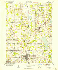 1951 Columbiana1953 Print · USGSThe Mahoning and Columbiana county line in the early fifties shows a landscape of rail-connected towns and rural cemeteries. Genealogists can trace family names at Zion Hill Ch Cem or Easterly Cem while exploring the rail routes of the ERIE RAILROAD.
 - 1951 Map of New Middletown, 1953 Print
 1951 New Middletown1953 Print · USGSEastern Ohio at the dawn of the fifties shows a rural landscape adapting to new interstate travel. Researchers can trace ancestral locations at Bethel Cem, Springfield High Sch, and the emerging corridor of the Ohio Turnpike.
 - 1952 Map of Alliance, 1954 Print
 1952 Alliance1954 Print · USGSAlliance and its surrounding industrial townships are captured in the early fifties, showcasing a dense rail and school network. Genealogists can trace family names through several burial sites like Old German Cem and Hartzell Cem, or locate historic homes near Mt Union College.3 unique versions available
 - 1952 Map of Damascus, 1954 Print
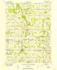 1952 Damascus1954 Print · USGSThe Mahoning and Columbiana county line comes alive in the early fifties, showing the rail-centered growth of Beloit and Damascus. Genealogists can locate family landmarks like the Damascus Cemetery, Township School, and the Wilbur Church at a time when steam and diesel still shared the rails.
 - 1952 Map of Salem, 1954 Print
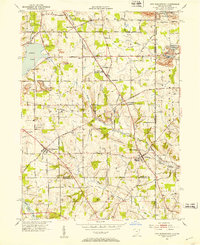
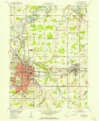
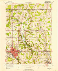 1952 Salem1954 Print · USGSMid-century development in the SALEM area shows a landscape of busy industrial towns and family-named crossroads during the 1950s. Genealogists and historians can trace neighborhood sites like Buckeye Sch, Hope Cem, and the old rail lines serving Washingtonville.
 - 1953 Map of Canton
 1953 Canton1953 Print · USGSThe industrial heartland of Ohio and Pennsylvania is captured at its mid-century peak in this detailed regional survey. Genealogists and historians can trace the vast rail networks of the Pennsylvania RR and find local landmarks like Nimisila Reservoir and Tappan Reservoir.
 - 1957 Map of Canton, 1971 Print
 1957 Canton1971 Print · USGSThe industrial heartland of eastern Ohio and western Pennsylvania comes alive in this mid-century survey of the Ohio River Valley. Trace the heritage of rail and river commerce through Pittsburgh, the massive steel towns along the Ohio River, and major junctions on the Pennsylvania RR.3 unique versions available
 - 1959 Map of Hanoverton, 1961 Print
 1959 Hanoverton1961 Print · USGSColumbiana County was a patchwork of family farms and small crossroads settlements in the late fifties. Genealogists and local historians can trace family locations near Hanoverton and North Georgetown or locate family plots at Woodsdale Cem and Figley Cem.2 unique versions available
End of results
Showing maps 1-9 of 9
Top cities of Columbiana County
- East Liverpool historical maps
- Salem historical maps
- Unity historical maps
- East Palestine historical maps
- Wellsville historical maps
- Lisbon historical maps
See more
Frequently asked questions
- What are the different types of historical maps available for Columbiana County?
- What is the oldest map of Columbiana County?
- Where can I purchase historical maps of Columbiana County for my home or office?
- Where can I download high-res historical maps of Columbiana County?
- Are there historical topographic maps available for Columbiana County?
- Is there historical aerial imagery available for Columbiana County?
- Where are historical maps of Columbiana County sourced from?