1990s Maps of Keene Township, Ohio
Explore 4 historic maps of Keene Township from the 1990s. These maps offer a rare glimpse into what life looked like during the 1990s — showing old roads, neighborhoods, homes, and landmarks that have changed or disappeared over time.
Whether you're researching your family's past, planning a metal detecting trip, or studying how Keene Township's landscape evolved across the 1990s, these high-resolution maps are a powerful tool for exploring the history of this region.
- Focus on a specific era: All maps on this page are from the 1990s, giving you a focused view of this time period.
- See what’s changed: Compare century-old streets, trails, and buildings to today's modern landscape using overlays and satellite layers.
- Research with precision: Use these maps for genealogy, historical research, land use analysis, or educational projects.
- View, download, or print: Maps are fully viewable online in high resolution, and can be downloaded or printed for your own records.
Start exploring Keene Township's history through authentic maps from the 1990s. This is your window into the past.
Keene Township, OH maps
(4)- 1994 Map of Killbuck, 1998 Print
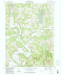 1994 Killbuck1998 Print · USGSHolmes and Coshocton Counties in the 1990s show a landscape of winding creeks and active resource extraction. Genealogists and local historians can trace family burial grounds like Salem Cem or follow the path of the old Railroad Grade near Blissfield.
 - 1994 Map of Coshocton, 1998 Print
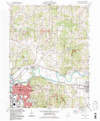 1994 Coshocton1998 Print · USGSThe rivers of Coshocton County meet in the late twentieth century as the industrial landscape and rural townships intersect. Genealogists can locate family landmarks like South Lawn Cemetery and Amity Cem or trace the old Canal Lewisville corridor.
 - 1994 Map of New Bedford, 1998 Print
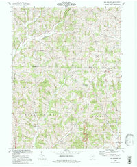 1994 New Bedford1998 Print · USGSThe rural borderlands of Holmes and Coshocton Counties are captured here in the late twentieth century. Researchers can trace family history through sites like Oak Hill Cem, Beeks Mills, and several country schools including Green Ridge Sch.
 - 1994 Map of Randle, 1998 Print
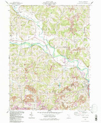 1994 Randle1998 Print · USGSThe confluence of the Walhonding River and Tuscarawas River comes to life in the 1990s as a hub of industrial and river history. Genealogists and hikers can trace an Old Railroad Grade, find rural burials at Antioch Cem, or locate landmarks like White Woman Rock.
End of results
Showing maps 1-4 of 4
Top cities near Keene Township
- Coshocton historical maps
- Berlin historical maps
- Walnut Creek historical maps
- Millersburg historical maps
- West Lafayette historical maps
- Sugarcreek historical maps
See more
Top neighborhoods of Keene Township
Frequently asked questions
- What are the different types of historical maps available for Keene Township?
- What is the oldest map of Keene Township?
- Where can I purchase historical maps of Keene Township for my home or office?
- Where can I download high-res historical maps of Keene Township?
- Are there historical topographic maps available for Keene Township?
- Is there historical aerial imagery available for Keene Township?
- Where are historical maps of Keene Township sourced from?