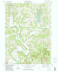
1994 Map of Killbuck
USGS Topo · Published 1998About this map
Killbuck Creek meanders through this borderland between Holmes and Coshocton Counties, defining a landscape where valley agriculture meets active extraction. The village of Killbuck anchors the northern reaches, while smaller settlements like Layland, Blissfield, and Helmick are scattered along the watercourse and its tributaries, including Wolf Creek and Laurel Creek. This late 20th-century revision reflects a terrain heavily shaped by resource use, evidenced by the extensive Oil Field and a prominent Strip Mine located in the eastern hills.
Find a feature on this map
38 named features on this map. Tap any name to fly to it.
Don’t see what you’re looking for? This feature index may not catch every label — zoom into the map to look around manually.
Map Details
Editions of this 1994 Killbuck Map
This is the sole edition of this map. No revisions or reprints were ever made.
Other maps of this area

1912 · Loudonville
USGS Topo · 1:62,500

1913 · Brinkhaven
USGS Topo · 1:62,500

1913 · Coshocton
USGS Topo · 1:62,500

1914 · Loudonville
USGS Topo · 1:62,500

1915 · Brinkhaven
USGS Topo · 1:62,500

1915 · Millersburg
USGS Topo · 1:62,500

1915 · Coshocton
USGS Topo · 1:62,500

1943 · Millersburg
USGS Topo · 1:62,500

1943 · Coshocton
USGS Topo · 1:62,500

1943 · Loudonville
USGS Topo · 1:62,500