
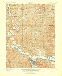
1915 Map of Coshocton
USGS Topo · Published 1939About this map
Coshocton and its industrial outskirts serve as the focal point of this 1912–1913 survey, where the Muskingum River forms at the confluence of the Walhonding and Tuscarawas. The landscape is a study in early 20th-century transportation, featuring the Ohio Canal with its Upper, Middle, and Lower Basins still clearly etched alongside the Pennsylvania and Wheeling and Lake Erie railroads. A notable engineering feature is the Sixmile Dam on the Walhonding River, which historically fed the canal system. North of the river valleys, the terrain rises into a dense network of rural school districts, including the Mound School and Greenhorn School, and small agricultural hubs like Becks Mills and Bloomfield Clark PO. The map also captures several distinct river crossings and the former canal town of Roscoe before its 20th-century preservation efforts, showing the area as a functional rail-and-water junction.
Find a feature on this map
93 named features on this map. Tap any name to fly to it.
Don’t see what you’re looking for? This feature index may not catch every label — zoom into the map to look around manually.
Map Details
Editions of this 1915 Coshocton Map
2 editions found
Other maps of this area

1908 · Conesville
USGS Topo · 1:62,500

1909 · Cambridge
USGS Topo · 1:62,500

1910 · Frazeysburg
USGS Topo · 1:62,500

1910 · Conesville
USGS Topo · 1:62,500

1911 · Newcomerstown
USGS Topo · 1:62,500

1912 · Cambridge
USGS Topo · 1:62,500

1912 · Loudonville
USGS Topo · 1:62,500

1913 · Newcomerstown
USGS Topo · 1:62,500

1913 · Brinkhaven
USGS Topo · 1:62,500

1913 · Coshocton
USGS Topo · 1:62,500