1960s Maps of Hollansburg, Ohio
Explore 2 historic maps of Hollansburg from the 1960s. These maps offer a rare glimpse into what life looked like during the 1960s — showing old roads, neighborhoods, homes, and landmarks that have changed or disappeared over time.
Whether you're researching your family's past, planning a metal detecting trip, or studying how Hollansburg's landscape evolved across the 1960s, these high-resolution maps are a powerful tool for exploring the history of this region.
- Focus on a specific era: All maps on this page are from the 1960s, giving you a focused view of this time period.
- See what’s changed: Compare century-old streets, trails, and buildings to today's modern landscape using overlays and satellite layers.
- Research with precision: Use these maps for genealogy, historical research, land use analysis, or educational projects.
- View, download, or print: Maps are fully viewable online in high resolution, and can be downloaded or printed for your own records.
Start exploring Hollansburg's history through authentic maps from the 1960s. This is your window into the past.
Hollansburg, OH maps
(2)- 1960 Map of Spartanburg, 1961 Print
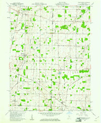 1960 Spartanburg1961 Print · USGSThe Indiana-Ohio borderlands at the start of the 1960s reveal a landscape of well-ordered farms and quiet railroad hamlets. Researchers can locate family landmarks like Beech Cemetery and Bartonia Cemetery or trace the New York Central through Crete.2 unique versions available
 - 1960 Map of Whitewater, 1961 Print
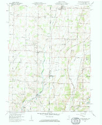 1960 Whitewater1961 Print · USGSThe Indiana-Ohio borderlands at the start of the sixties reveal a landscape of thriving crossroads and river-valley farms. Genealogists can trace family footprints through the Middleboro settlement, Friendship Ch, and several rural burial grounds like Bethel Cem.3 unique versions available
End of results
Showing maps 1-2 of 2
Top cities near Hollansburg
- Richmond historical maps
- Greenville historical maps
- Eaton historical maps
- Winchester historical maps
- Union City historical maps
- Centerville historical maps
See more
Frequently asked questions
- What are the different types of historical maps available for Hollansburg?
- What is the oldest map of Hollansburg?
- Where can I purchase historical maps of Hollansburg for my home or office?
- Where can I download high-res historical maps of Hollansburg?
- Are there historical topographic maps available for Hollansburg?
- Is there historical aerial imagery available for Hollansburg?
- Where are historical maps of Hollansburg sourced from?