1960s Maps of Farmer Township, Ohio
Explore 4 historic maps of Farmer Township from the 1960s. These maps offer a rare glimpse into what life looked like during the 1960s — showing old roads, neighborhoods, homes, and landmarks that have changed or disappeared over time.
Whether you're researching your family's past, planning a metal detecting trip, or studying how Farmer Township's landscape evolved across the 1960s, these high-resolution maps are a powerful tool for exploring the history of this region.
- Focus on a specific era: All maps on this page are from the 1960s, giving you a focused view of this time period.
- See what’s changed: Compare century-old streets, trails, and buildings to today's modern landscape using overlays and satellite layers.
- Research with precision: Use these maps for genealogy, historical research, land use analysis, or educational projects.
- View, download, or print: Maps are fully viewable online in high resolution, and can be downloaded or printed for your own records.
Start exploring Farmer Township's history through authentic maps from the 1960s. This is your window into the past.
Farmer Township, OH maps
(4)- 1960 Map of Sherwood, 1961 Print
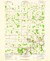 1960 Sherwood1961 Print · USGSDefiance and Paulding counties appear here at a mid-century peak of rail and river utility, anchored by the junction at Sherwood. Genealogists and local historians can trace family road names and locate rural landmarks like Glore Cem, The Bend, and St Johns Ch.2 unique versions available
 - 1960 Map of Bryan, 1961 Print
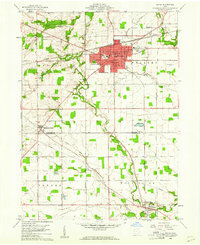 1960 Bryan1961 Print · USGSThe Northwest Ohio landscape of the early sixties comes alive around Bryan and the winding Lick Creek. Genealogists and local historians can trace rural roots through Brown Cem, Washington Sch, and the small settlement of Ney.4 unique versions available
 - 1961 Map of Mark Center, 1962 Print
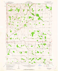 1961 Mark Center1962 Print · USGSNorthwestern Ohio's rural landscape is documented here in the early sixties as it straddled the Defiance and Paulding county line. Researchers can trace the path of the Baltimore and Ohio railroad past landmarks like the Township High Sch, Six Corners, and several family cemeteries.2 unique versions available
 - 1961 Map of Edgerton, 1962 Print
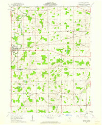 1961 Edgerton1962 Print · USGSIn the early sixties, the Williams and Defiance County line was a landscape of quiet crossroads and bustling rail stops. Trace family history and rural industry through Edgerton, the trackside hamlet of Mina, and local landmarks like Tamarack Cem.3 unique versions available
End of results
Showing maps 1-4 of 4
Top cities near Farmer Township
- Defiance historical maps
- Bryan historical maps
- Montpelier historical maps
- Paulding historical maps
- Hicksville historical maps
- Butler historical maps
See more
Top neighborhoods of Farmer Township
Frequently asked questions
- What are the different types of historical maps available for Farmer Township?
- What is the oldest map of Farmer Township?
- Where can I purchase historical maps of Farmer Township for my home or office?
- Where can I download high-res historical maps of Farmer Township?
- Are there historical topographic maps available for Farmer Township?
- Is there historical aerial imagery available for Farmer Township?
- Where are historical maps of Farmer Township sourced from?