1960s Maps of Fulton County, Ohio
Explore 12 historic maps of Fulton County from the 1960s. These maps offer a rare glimpse into what life looked like during the 1960s — showing old roads, neighborhoods, homes, and landmarks that have changed or disappeared over time.
Whether you're researching your family's past, planning a metal detecting trip, or studying how Fulton County's landscape evolved across the 1960s, these high-resolution maps are a powerful tool for exploring the history of this region.
- Focus on a specific era: All maps on this page are from the 1960s, giving you a focused view of this time period.
- See what’s changed: Compare century-old streets, trails, and buildings to today's modern landscape using overlays and satellite layers.
- Research with precision: Use these maps for genealogy, historical research, land use analysis, or educational projects.
- View, download, or print: Maps are fully viewable online in high resolution, and can be downloaded or printed for your own records.
Start exploring Fulton County's history through authentic maps from the 1960s. This is your window into the past.
Fulton County, OH maps
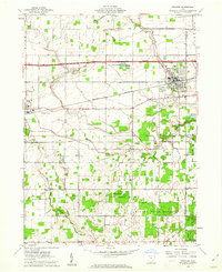
(12)- 1960 Map of Napoleon East, 1961 Print
 1960 Napoleon East1961 Print · USGSHenry County in the early sixties shows a landscape shaped by the river and the rail, as the towns of Napoleon and Liberty Center anchored this farming region. Genealogists can locate family sites at Forest Hill Cemetery, Liberty Chapel, and along the old route of the Miami and Erie Canal.3 unique versions available
 - 1960 Map of Wauseon, 1961 Print
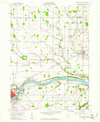
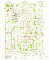
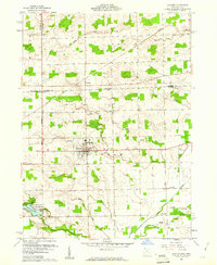
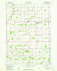
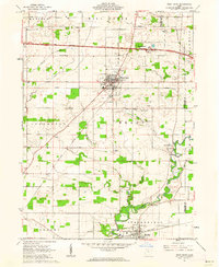
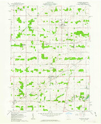
 1960 Wauseon1961 Print · USGSFulton County agricultural life and mid-century transit are frozen in time just as the interstate era reshaped the landscape. Researchers can trace family sites like Aeschliman Cem, the old Ottokee Station, and local landmarks like the Drive-in Theater.3 unique versions available
 - 1960 Map of Colton, 1961 Print
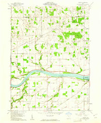 1960 Colton1961 Print · USGSHenry County and the Maumee River valley are shown in the early 1960s as a landscape of timbered forests and precise rail-side villages. Researchers can locate family landmarks like Mohler-Union Cem, Damascus Ch, and the riverside Grand Rapids Dam.3 unique versions available
 - 1960 Map of Morenci, 1961 Print
 1960 Morenci1961 Print · USGSMorenci and the surrounding borderlands of Michigan and Ohio are shown here in the early sixties, as rail lines and rural townships defined the local economy. Genealogists can trace family names through Oak Grove Cemetery, East Chesterfield Ch, and the crossroads at Oakshade.3 unique versions available
 - 1960 Map of Fayette, 1961 Print
 1960 Fayette1961 Print · USGSThe borderlands of Fulton County and Michigan come into focus in this 1960s survey of Fayette. Family historians can trace local landmarks like Snow Cem, the grounds of Camp Palmer, and the rural crossroads of Munson and Powers.4 unique versions available
 - 1960 Map of Lyons, 1961 Print
 1960 Lyons1961 Print · USGSNorthwest Ohio's borderlands are mapped here in the early sixties, showing the rural landscape around Lyons and Winameg. Researchers can trace old family sites and transit routes including the Detroit Toledo and Ironton railroad, Rose Hill Cem, and Tubbs Sch.3 unique versions available
 - 1960 Map of Delta, 1962 Print
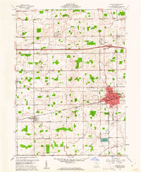
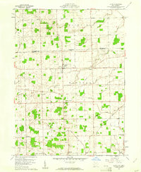
 1960 Delta1962 Print · USGSThe rail and road networks of Fulton County are on full display during the early sixties, centered on the growing hub of Delta. Researchers can trace old family lines through Greenlawn Cemetery or locate rural landmarks like the Swan Creek Ch and Grieser Airport.3 unique versions available
 - 1960 Map of Swanton, 1962 Print
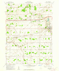
 1960 Swanton1962 Print · USGSSwanton and Delta appear at the height of the mid-century era, situated along a busy intersection of historic rail lines and the modern turnpike. Researchers can trace rural lineages through landmarks like Centerville Cem, Baker Ch, and the small settlement of Ai.2 unique versions available
 - 1960 Map of Assumption, 1962 Print
 1960 Assumption1962 Print · USGSFulton County and the borderlands of Lenawee County appear here in a period of quiet agricultural stability. Researchers can trace the Detroit Toledo and Ironton rail line through Metamora or locate rural sites like Lytton and Peebles Cem.3 unique versions available
 - 1961 Map of Toledo
 1961 Toledo1961 Print · USGSThe western basin of Lake Erie and the industrial heart of Northern Ohio are captured here during the post-war era. Researchers can trace historical rail lines like the New York Central or locate landmarks like the Erie Ordnance Depot and Pelee Island.
 - 1961 Map of West Unity, 1962 Print
 1961 West Unity1962 Print · USGSWilliams County at the start of the sixties shows a landscape defined by the Tiffin River and the new Ohio Turnpike. Researchers can trace family history at the Quaker Ch Cem or explore the rail era through West Unity and Stryker.2 unique versions available
 - 1961 Map of Alvordton, 1963 Print
 1961 Alvordton1963 Print · USGSCrossing the Michigan-Ohio border in the early sixties, this area reveals a network of small rail towns and rural parishes. Researchers can trace family history at Walnut Grove Cem, locate the former Franklin Junction rail stop, or explore the grounds of Harrison Lake State Reservation.2 unique versions available
End of results
Showing maps 1-12 of 12
Top cities of Fulton County
- Wauseon historical maps
- Archbold historical maps
- Delta historical maps
- Fayette historical maps
- Metamora historical maps
- Lyons historical maps
Frequently asked questions
- What are the different types of historical maps available for Fulton County?
- What is the oldest map of Fulton County?
- Where can I purchase historical maps of Fulton County for my home or office?
- Where can I download high-res historical maps of Fulton County?
- Are there historical topographic maps available for Fulton County?
- Is there historical aerial imagery available for Fulton County?
- Where are historical maps of Fulton County sourced from?