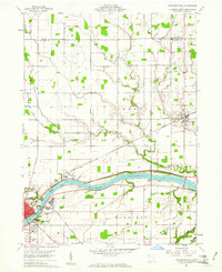
1960 Map of Napoleon East
USGS Topo · Published 1961About this map
The Maumee River corridor in Henry County defines this landscape, where the vestiges of early Ohio transportation meet the agricultural grid of the mid-20th century. Just north of the river, the Miami and Erie Canal (Abandoned) remains visible, tracing a path parallel to the water through Damascus Cem. This infrastructure is layered with the Wabash and the Toledo Detroit and Ironton railroads, which served the hubs of Napoleon and Liberty Center. Local genealogy is well-represented through numerous landmarks, including Forest Hill Cemetery and Young Cem, as well as rural congregations like Liberty Chapel and Sharon Ch. The map captures a period of established local industry and community life, evidenced by the Fairground, the Southside Sch, and the presence of a Sandpit in Harrison township.
Find a feature on this map
33 named features on this map. Tap any name to fly to it.
Don’t see what you’re looking for? This feature index may not catch every label — zoom into the map to look around manually.
Map Details
Editions of this 1960 Napoleon East Map
Other maps of this area

1908 · Napoleon
USGS Topo · 1:62,500

1909 · Mc Clure
USGS Topo · 1:62,500

1911 · Wauseon
USGS Topo · 1:62,500

1911 · Swanton
USGS Topo · 1:62,500

1913 · Wauseon
USGS Topo · 1:62,500

1914 · Swanton
USGS Topo · 1:62,500

1943 · Wauseon
USGS Topo · 1:62,500

1953 · Fort Wayne
USGS Topo · 1:250,000

1956 · Fort Wayne
USGS Topo · 1:250,000

1956 · Toledo
USGS Topo · 1:250,000