1910s Maps of Pettisville, Ohio
Explore 2 historic maps of Pettisville from the 1910s. These maps offer a rare glimpse into what life looked like during the 1910s — showing old roads, neighborhoods, homes, and landmarks that have changed or disappeared over time.
Whether you're researching your family's past, planning a metal detecting trip, or studying how Pettisville's landscape evolved across the 1910s, these high-resolution maps are a powerful tool for exploring the history of this region.
- Focus on a specific era: All maps on this page are from the 1910s, giving you a focused view of this time period.
- See what’s changed: Compare century-old streets, trails, and buildings to today's modern landscape using overlays and satellite layers.
- Research with precision: Use these maps for genealogy, historical research, land use analysis, or educational projects.
- View, download, or print: Maps are fully viewable online in high resolution, and can be downloaded or printed for your own records.
Start exploring Pettisville's history through authentic maps from the 1910s. This is your window into the past.
Pettisville, OH maps
(2)- 1911 Map of Wauseon, 1954 Print
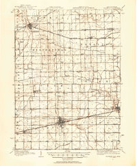 1911 Wauseon1954 Print · USGSFulton County and the Michigan-Ohio borderlands thrived as a major railroad hub in the early twentieth century. Researchers can trace numerous vanished district schools like Swamp Angel School and stop-points like Tedrow PO or Ottokee Sta.
 - 1913 Map of Wauseon
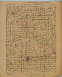 1913 Wauseon1913 Print · USGSFulton County and the Michigan-Ohio border are shown here just before the Great War, during the peak of the region's rural school and rail networks. Genealogists can locate specific family-named landmarks and institutions like Tedrow PO, Ottokee, and the Swamp Angel School.2 unique versions available
End of results
Showing maps 1-2 of 2
Top cities near Pettisville
- Defiance historical maps
- Napoleon historical maps
- Wauseon historical maps
- Archbold historical maps
- Delta historical maps
- Morenci historical maps
See more
Frequently asked questions
- What are the different types of historical maps available for Pettisville?
- What is the oldest map of Pettisville?
- Where can I purchase historical maps of Pettisville for my home or office?
- Where can I download high-res historical maps of Pettisville?
- Are there historical topographic maps available for Pettisville?
- Is there historical aerial imagery available for Pettisville?
- Where are historical maps of Pettisville sourced from?