1900-1909 Maps of Edoma Trail Subdivision, Raccoon Township
Explore 2 historic maps of Edoma Trail Subdivision from 1900-1909. These maps offer a rare glimpse into what life looked like during the 1900s — showing old roads, neighborhoods, homes, and landmarks that have changed or disappeared over time.
Whether you're researching your family's past, planning a metal detecting trip, or studying how Edoma Trail Subdivision's landscape evolved across the 1900s, these high-resolution maps are a powerful tool for exploring the history of this region.
- Focus on a specific era: All maps on this page are from the 1900s, giving you a focused view of this time period.
- See what’s changed: Compare century-old streets, trails, and buildings to today's modern landscape using overlays and satellite layers.
- Research with precision: Use these maps for genealogy, historical research, land use analysis, or educational projects.
- View, download, or print: Maps are fully viewable online in high resolution, and can be downloaded or printed for your own records.
Start exploring Edoma Trail Subdivision's history through authentic maps from the 1900s. This is your window into the past.
Edoma Trail Subdivision, Raccoon Township maps
(2)- 1906 Map of Bidwell, 1954 Print
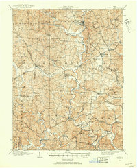 1906 Bidwell1954 Print · USGSGallia County at the turn of the century is a network of small townships and valley settlements connected by the Gallipolis and Chillicothe RR. Researchers can trace rural life through a wealth of local landmarks like Centerville Thurman PO, Ghee Bridge, and the Tomato Valley School.
 - 1908 Map of Bidwell
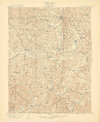 1908 Bidwell1908 Print · USGSGallia County at the turn of the century is a landscape of creek-side hamlets and hill-country schools. Genealogists can trace family roots through numerous local landmarks like Tomato Valley School, Tabor Church, and the Centerville Thurman P O post office.2 unique versions available
End of results
Showing maps 1-2 of 2
Top cities near Edoma Trail Subdivision
- Wellston historical maps
- Point Pleasant historical maps
- Gallipolis historical maps
- Addison historical maps
- Oak Hill historical maps
- Rio Grande historical maps
See more
Frequently asked questions
- What are the different types of historical maps available for Edoma Trail Subdivision?
- What is the oldest map of Edoma Trail Subdivision?
- Where can I purchase historical maps of Edoma Trail Subdivision for my home or office?
- Where can I download high-res historical maps of Edoma Trail Subdivision?
- Are there historical topographic maps available for Edoma Trail Subdivision?
- Is there historical aerial imagery available for Edoma Trail Subdivision?
- Where are historical maps of Edoma Trail Subdivision sourced from?